On Alt. US 13 Front Street at T. C. Walker Drive, on the right when traveling north on Alt. US 13 Front Street.
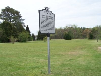
The first high school for blacks in Accomack County was dedicated on this site in 1932. It was named in honor of Mary Nottingham Smith (1892-1951), a black educator who dedicated her life to educating all young people. In 1956, the school was . . . — — Map (db m7822) HM
On Main Street at Mumford Street, on the right when traveling west on Main Street.
Built in 1887, this Queen Anne style commercial building was originally the O.M. Jones Drug Store. In 1908, the building became Wallace "Tig" Jester's barber shop. For 75 years, Tig offered a shave, haircut, and gathering place for island men. In . . . — — Map (db m165065) HM
On Junior Lane at Dockview Street, on the right when traveling west on Junior Lane.
Built in 1907 the buildings first floor was used for classrooms while the second floor was a meeting room for a fraternal lodge. Although the building served as a public school offering three years of high school classes, it was privately built and . . . — — Map (db m151385) HM
On Adams Crossing Road at US 13, on the right when traveling east on Adams Crossing Road.
Two miles east, on Route 600, meets what is possibly the nation's oldest continuous Sunday School. Begun by William Elliott in his home in 1785, it was moved in 1816 to Burton's Chapel and in 1870 to the present church. — — Map (db m7615) HM
On Main Ridge Road at Dise Lane, on the left when traveling south on Main Ridge Road.
The New Testament Congregation was dedicated on Easter Sunday, 1957, and occupies the same site used for the Chautauqua tent in the 1920's.
The New Testament Mission House was once the home of teacher Alfred Benson (1893-1963) who taught at . . . — — Map (db m207732) HM
On Main Ridge Road at Twin John Lane, on the left when traveling south on Main Ridge Road.
This is the site of the former Lewis Crockett Store. It is also the site where in 1936, the Goodyear Blimp arrived with provisions to feed the islanders, who had been frozen in for over two months during a record freeze.
The Visitors Center . . . — — Map (db m106969) HM
Near Chincoteague Road (Virginia Route 175) 2.3 miles north of Atlantic Road.
Dedicated in honor of
Dr. Robert L. Krieger
1916 - 1990
Leader of Wallops from 1948-1981, he guided the facility through years of expansion and research, He was very involved in educational and civic activities on the Eastern . . . — — Map (db m205051) HM
On North Milton Road (County Route 729) 0.1 miles south of Richmond Road (U.S. 250).
On 3 Sept. 1963, nine years after the U.S. Supreme Court declared racial segregation of public schools unconstitutional, 26 African-American students desegregated Albemarle High, Stone-Robinson Elementary, and Greenwood School. With the . . . — — Map (db m170122) HM
On Richmond Road (U.S. 250) 0.1 miles west of Louisa Road (Virginia Route 22), on the right when traveling west.
William Randolph patented the Edgehill plantation just to the north, in 1735. His grandson, Thomas Mann Randolph, married Thomas Jefferson's daughter Martha, acquired Edgehill in 1792, and was later governor of Virginia. The couple built a frame . . . — — Map (db m170657) HM
Born in slavery at Monticello on July 4, 1826, the day of Thomas Jefferson's death, Henry Martin worked at the University in various capacities from about 1847 until his retirement in 1910. In late 1868 or early 1869, he was employed as head . . . — — Map (db m75526) HM
On McCormick Road south of University Avenue (Business U.S. 250), on the left when traveling south.
In 1788 James Monroe purchased an 800-acre farm here to be close to his friend Thomas Jefferson and to establish a law office. In 1799 the Monroes moved to their new Highland plantation adjacent to Monticello and sold the first farm. In 1817 the . . . — — Map (db m8762) HM
On University Avenue (Business U.S. 250) at Hospital Drive, on the right when traveling west on University Avenue.
In the early 1900s “The Corner,” so named by the University crowd, was but a sparse collection of businesses at the entrance to the University Grounds—literally just a corner. In the intervening years “The Corner” . . . — — Map (db m86177) HM
On University Avenue (Virginia Route 250) east of McCormick Road, on the left when traveling west.
Proclaim Liberty throughtout the land unto the inhabitants thereof —Leviticus XXIV.
This monument to Thomas Jefferson was presented to the people to perpetuate the teachings and examples of the Founders of the . . . — — Map (db m8805) HM
On Ivy Road (Business U.S. 250) just west of Colonnade Drive, on the right when traveling east.
On 3 Mar. 1865, after the Battle of Waynesboro, Maj. Gen. Philip H. Sheridan's Union Army of the Shenandoah entered Charlottesville. As Bvt. Maj. Gen. George A. Custer's 3d Cavalry Division arrived, Mayor Christopher L. Fowler, local officials, and . . . — — Map (db m170640) HM
William Holding Echols (1859–1934), Professor of Mathematics, lived in this pavilion. By precept and example, he taught many generations of students with ruthless insistence that the supreme values are self respect, integrity of mind, contempt . . . — — Map (db m62645) HM
Near University Avenue (Business U.S. 250) east of McCormick Road, on the left when traveling west.
In memory of
Woodrow Wilson
student of this university 1879-1881
President of the United States 1913-1921
Founder of the League of Nations 1919 — — Map (db m230788) HM
Near University Avenue (Business U.S. 250) east of McCormick Road, on the left when traveling west.
In memory of the sons of this University who gave their lives for freedom in the World War
Robert Dunaway Adams •
George Wayne Anderson, Jr. •
Adair Pleasants Archer •
Samuel Chandler Baker •
Andrew Beirne Blair, Jr. •
William Ewing . . . — — Map (db m230736) WM
Near Hydraulic Road (County Road 743) at Hydraulic Ridge Road, on the left when traveling north.
On 3 Sept. 1963, nine years after the U.S. Supreme Court declared racial segregation of public schools unconstitutional, 26 African-American students formerly enrolled at all-black schools desegregated Albemarle High School, Stone-Robinson . . . — — Map (db m170167) HM
On West Main Street at 1st Street North, on the left when traveling east on West Main Street.
The name Jefferson School has a long association with African American education in Charlottesville. It was first used in the 1860s in a Freedmen's Bureau school and then for a public grade school by 1894. Jefferson High School opened here in 1926 . . . — — Map (db m246922) HM
On McCormick Road at Poe Alley, on the right when traveling south on McCormick Road.
"I feel fortunate to have had the opportunity to be a part of this suit and to watch it unfold. I am grateful for the outcome which enabled me to receive an education that enriched my life across many dimensions."
-Virginia . . . — — Map (db m246897) HM
Near West Pavilion just north of Constantine Path, on the left when traveling north.
In a Washington Post article covering the Rebellion, Hayes said "we want to preserve…the dignity of those who work here… We must end racism, we must end bigotry. In this school, in Virginia and in the country.
On Rotunda Drive west of Hospital Drive, on the right when traveling west.
As it enters its third century, the University of Virginia remembers the enslaved people whose labor and talents made possible the construction and operation of the Academical Village. Forced labor, incalculable suffering, and the struggle to . . . — — Map (db m246928) HM
On University Avenue (Business U.S. 250) at Rugby Road on University Avenue.
Thomas Jefferson founded the University of Virginia. The cornerstone of its first building was laid on October 6, 1817, in the presence of three presidents of the United States—Jefferson, James Madison, and James Monroe. In 1825, the . . . — — Map (db m61101) HM
On St John Road (Virginia Route 640) 1 mile south of Gordonsville Road (Route 231), on the right when traveling south.
The St. John School, built here in 1922–1923, served African-American students during the segregation era. Julius Rosenwald, president of Sears Roebuck and Co., collaborated with Booker T. Washington in a school-building campaign begining in . . . — — Map (db m102560) HM
On Louisa Road (Virginia Route 22) 0.1 miles west of Whitlock Road (Virginia Route 616), on the left when traveling west.
Albemarle County. Albemarle County was formed in 1744 from Goochland County and named for William Anne Keppel, the second Earl of Albemarle, titular governor of Virginia from 1737 to 1754. A portion of Louisa County was later added to . . . — — Map (db m22780) HM
On Greenwood Road (County Route 691) 0.2 miles north of Greenwood Station Road (County Route 690), on the right when traveling north.
On 3 Sept. 1963, nine years after the U.S. Supreme Court
declared racial segregation of public schools unconstitutional,
26 African-American students formerly enrolled at all-black
schools desegregated Albemarle High School, . . . — — Map (db m234288) HM
On Virginia Route 231 north of Lindsay Road, on the left when traveling north.
Just north was a classical school conducted by the Rev. James Maury, rector of Fredericksville Parish from 1754 to 1769. Thomas Jefferson was one of Maury’s students. Matthew Fontaine Maury, the “Pathfinder of the Seas,” was Maury’s . . . — — Map (db m17459) HM
On Miller School Road (County Route 635) close to Dick Woods Road (County Route 637), on the left when traveling south.
A bequest of Samuel Miller (1792–1869) provided funds to found the Miller School in 1878. Miller, a Lynchburg businessman born in poverty in Albemarle County, envisioned a regional school for children who could not afford an education. The school . . . — — Map (db m21699) HM
On James Monroe Parkway (County Route 795) 0.8 miles south of Thomas Jefferson Parkway (Virginia Route 53), on the left when traveling south.
This estate was the home of James Monroe, fifth president of the United States. In 1793, James and Elizabeth Kortright Monroe purchased 1,000 acres adjoining Jefferson’s Monticello. Called Highland, the plantation, eventually totaling 3,500 acres, . . . — — Map (db m23437) HM
On Mark Center Avenue at Mark Center Drive, on the left when traveling west on Mark Center Avenue.
This land was once part of more than 1,100 acres acquired by the Terrett family by the mid-19th century. Within Fairfax County until annexed by the City of Alexandria in 1952, the area was primarily agricultural fieldsd and woodlands here before . . . — — Map (db m214230) HM
On Holland Lane at Jamieson Avenue, on the right when traveling north on Holland Lane.
[Plaque on the left side of the entrance:]
From the establishment of Alexandria in 1749 to the present time, African Americans have been a vibrant part of this city's history. The City of Alexandria would not exist in its present form were . . . — — Map (db m131547) HM
On King Street (Virginia Route 7) 0.1 miles east of Marlee Way, on the right when traveling east.
Three roads formed this Fairfax County intersection by the early 19th century. Braddock Road, Middle Turnpike (later called Leesburg Pike/King Street/Route 7) and Quaker Lane were the wagon routes for trade between the port town of Alexandria and . . . — — Map (db m150816) HM
On King Street (Virginia Route 7) near South Taylor Street, on the right when traveling east.
Episcopal High School, on the hill to the southwest, was founded in 1839 as a boys' preparatory school, one of the first in the South; girls were admitted in 1991. The school was a pioneer in the establishment of student honor codes in preparatory . . . — — Map (db m7559) HM
On King Street (Virginia Route 7) near South Taylor Street, on the right when traveling east.
Half mile to the southwest. The idea for such an institution was conceived by a group of Alexandria and Washington clergymen in 1818. Among those interested was Francis Scott Key, author of the Star Spangled Banner. Originally at corner of . . . — — Map (db m7561) HM
Near Wolfe Street east of South Washington Street, on the right when traveling east.
Erected 1785, Chartered by the General Assembly of Virginia 1786, with the following trustees:
George Washington
William Brown
John Fitzgerald
William Baker
Samuel Hanson
William Hartshorne
Benjamin Dulany
David Stuart
Charles . . . — — Map (db m175873) HM
On King Street (Virginia Route 7) at North Fayette Street, on the right when traveling west on King Street.
Just two blocks north of this location along Fayette Street (named for the Marquis de Lafayette who visited Alexandria in 1824), near the southwest corner of Queen Street, stood the Old Powder House, dating from 1791-1809. On the same spot, the . . . — — Map (db m115713) HM
On King Street (Virginia Route 7) at North West Street, on the right when traveling west on King Street.
The building at 1315 Duke Street, two blocks south of here, was originally built around 1812 as a residence for General Robert Young, commander of Alexandria's militia, who died in 1824. This three-story brick building then became the . . . — — Map (db m115706) HM
On Oronoco Street east of North Washington Street (Virginia Route 400), on the right when traveling east. Reported permanently removed.
Robert E. Lee left this home that he loves so well to enter West Point. After Appomattox he returned and climbed the wall to see “if the snowballs were in bloom.” George Washington dined here when it was the home of William Fitzhugh, Lee’s kinsman . . . — — Map (db m8548) HM
On The Strand at Prince Street, on the right when traveling north on The Strand.
"Ready All…Row!"
Beginning in 1880
ODBC was founded in 1880 as a rowing, recreational, and athletic club in Alexandria.
The Club won its first rowing regatta in 1887 and continues to support rowing to this day.
The . . . — — Map (db m195593) HM
On The Strand just south of Prince Street, on the right when traveling north.
The Old Dominion Boat Club's objective is to promote charitable and community service, athletic and water-related activities, and fellowship among its members.
Alexandria's Sportsman's Club
1947 - Present
Founded on an idea by . . . — — Map (db m195633) HM
On Prince Street east of South Columbus Street, on the right when traveling east. Reported permanently removed.
Built in 1802 by Thomas Swann
Purchased in 1832 by
Henry Daingerfield and enlarged.
St. Mary's Academy 1889 - 1943
Restored in 1978 by
Mr. and Mrs. Hugh E. Witt
— — Map (db m134974) HM
On Prince Street east of South Columbus Street, on the right when traveling east.
A private residence listed in the National Register of Historic Places by the United States Department of the Interior. Registered as a Virginia Historic Landmark by the Virginia Board of Historic Resources.
Thomas Swann House, 1802-1833. . . . — — Map (db m145963) HM
On King Street (Virginia Route 7) at North Washington Street (Virginia Route 400), on the right when traveling east on King Street.
One block south is The Alexandria Lyceum, formed as a public education organization in 1834 by Quaker schoolmaster Benjamin Hallowell and other civic leaders. In 1839, the founders joined with the Alexandria Library Company to construct a . . . — — Map (db m115718) HM
On South Washington Street (Virginia Route 400) south of Prince Street, on the right when traveling south.
Built in 1839 by the Alexandria Lyceum Company under the leadership of Benjamin Hallowell, this building housed the Alexandria Library and was the scene of concerts, meetings, debates and lectures featuring such speakers as John Quincy Adams and . . . — — Map (db m8607) HM
On North Alfred Street just south of Wythe Street, on the right when traveling south.
This is the original entrance to the Robert H. Robinson Library, built in 1940 as the segregated facility for Alexandria's African American residents. — — Map (db m188812) HM
On Queen Street just east of North Columbus Street, on the right when traveling west.
On August 21, 1939, five young African-American men, William Evans, Edward Gaddis, Morris Murray, Clarence Strange and Otto Tucker entered the Barrett Library, then a whites-only segregated, public facility. When they requested library cards and . . . — — Map (db m195649) HM
On North Fayette Street south of Queen Street, on the right when traveling south.
This modest, wood-frame building has played an important role in the segregated history of Alexandria. During World War II, the federal government encouraged women to join the war effort by providing safe and affordable day care. In Alexandria, . . . — — Map (db m129190) HM
On Montgomery Street just east of Richmond Highway (U.S. 1), on the left when traveling west.
Earl Lloyd, a Naismith Memorial Basketball Hall of Famer, grew up on this block, attended the segregated Parker-Gray High School, and graduated from West Virginia State College. On 31 Oct. 1950, as a member of the Washington Capitols, he became the . . . — — Map (db m195657) HM
On Oronoco Street at North Washington Street (Virginia Route 400), on the right when traveling east on Oronoco Street.
Built by Philip Richard Fendall in 1785 on land purchased from Henry (Light Horse Harry) Lee. Lee was a brilliant cavalry officer in the Revolution, close friend of George Washington, Virginia Assemblyman, member of Congress and Governor of . . . — — Map (db m128768) HM
The first story was built in 1812 as the first female free school in Virginia endowed by Mrs. Martha Washington and Mr. W. B. Dandredge.
Potomac Lodge No. 38 of the Independent Order of Odd Fellows purchased the property on November 15, 1841 and . . . — — Map (db m67083) HM
Parker-Gray School opened on Wythe Street in 1920 to serve African American students in grades 1-8. Until upper-level classes were added in 1932, African Americans had to travel to the District of Columbia to attend high school. Civil rights . . . — — Map (db m98083) HM
On Wythe Street at North Alfred Street, on the right when traveling east on Wythe Street.
Panel 1:
In the summer of 1939, Attorney Samuel W. Tucker organized six youths — William Evans, Otto Tucker, Edward Caddis, Morris Murray, Clarence Strange, and Robert Strange — for a “sit-in” at the segregated . . . — — Map (db m141636) HM
On Wythe Street just east of North Patrick Street (U.S. 1), on the right when traveling west.
Enforced racial segregation in Alexandria meant separate, poorly funded schools for the City's African American students. Here, in the African American neighborhood then known as Uptown, a new school was built in 1920 at 901 Wythe Street for . . . — — Map (db m182228) HM
Near Madison Street just east of North Patrick Street (U.S. 1), on the right when traveling east.
Parker-Gray High School served Alexandria's African American students—first on Wythe Street and later on Madison Street—during the City's years of enforced school segregation. With little support from the City, the school's faculty and coaches . . . — — Map (db m195656) HM
On Princess Street just east of North Patrick Street (U.S. 1), on the left when traveling east.
Alexandria, occupied by Union troops in 1861, attracted many African Americans escaping slavery. In Jan. 1864, a group of formerly enslaved people organized Third Freedmen's Baptist Church (later Third Baptist Church). The congregation moved to this . . . — — Map (db m140583) HM
On Edison Street north of Mark Drive, on the left when traveling north.
Betty King was a scientist, teacher, community activist, photographer, mother, grandmother, neighbor, and friend who lived in the Hume Springs neighborhood in north Alexandria from the early 1980's until she passed away in her home on Mark Drive on . . . — — Map (db m130985) HM
On Mount Vernon Avenue at East Spring Street, on the right when traveling north on Mount Vernon Avenue.
Dedicated to the memory of those of our boys who served in World War II and did not come back
Erected by the graduating classes of 1943**1944**1945**1946**1947
(west side)
Robert Rumshin • Herbert Joseph Petrello • Benjamin J. . . . — — Map (db m80571) WM
On Mt. Vernon Avenue at Adams Avenue, on the right when traveling north on Mt. Vernon Avenue.
The City of Alexandria purchased 15.5 acres here in 1933 and opened George Washington High School in 1935. For two decades this was the city's only public high school for white students. The Art Deco-style building was constructed with funding from . . . — — Map (db m202869) HM
On Mount Vernon Avenue at Stewart Avenue, on the left when traveling north on Mount Vernon Avenue.
In September 1900, Alexandria County opened the original Mount Vernon School on this property to educate children up to the 8th grade. In spite of continual expansion, crowding was always a problem. By 1932, it was necessary to rent the bank . . . — — Map (db m115682) HM
Near West Braddock Road, 0.1 miles east of North Howard Street, on the left when traveling east.
Clara Shorts Adams and Robert Adams conveyed a quarter-acre to the Falls Church School District of Fairfax County in 1898 for the purpose of educating African American children. The one-room "Colored School Building at Seminary" was the first . . . — — Map (db m167217) HM
On Washington Street (Virginia Route 400) at Wolfe Street, on the right when traveling north on Washington Street.
On 17 Dec. 1785, George Washington endowed a school here in the recently established Alexandria Academy “for the purpose of educating orphan children.” In 1812, an association of free African Americans founded its own school here in space vacated by . . . — — Map (db m813) HM
On South Washington Street north of Wolfe Street, on the right when traveling north.
African Americans escaping slavery found refuge in Alexandria after Union troops occupied the city in 1861. The Rev. Clement “Clem” Robinson established the First Select Colored School in 1862. Hundreds of students registered for day and . . . — — Map (db m98079) HM
On South Washington Street (Virginia Route 400) south of Gibbon Street, on the right when traveling north.
At the end of the 18th century, African Americans constituted half of the congregation at Alexandria's Trinity Methodist Episcopal Church. With support from Trinity, black members founded a separate congregation early in the 1830s, and their . . . — — Map (db m127781) HM
On South Washington Street (Virginia Route 400) south of Wolfe Street, on the right when traveling north.
Alexandria Academy
(Washington School)
Built 1785-86
George Washington member
Board of Managers
Washington Lancastrian School
(Site of)
Built 1812
Razed 1870
Alexandria Community Y
Erected . . . — — Map (db m129166) HM
Near Callahan Drive south of King Street (Virginia Route 7), on the right when traveling south.
has been designated a National Historic Landmark
This site possesses national significance in commemorating the history of the United States of America.
Built from 1922-1932 to symbolize George Washington's character and virtue, this . . . — — Map (db m204971) HM
Near Grub Hill Church Road (Virginia Route 609) 0.4 miles north of Ruffin Lane (Virginia Route 716), on the right when traveling north.
Tabb was born in 1845 at "The Forest" here in Amelia County into one of Virginia's oldest and wealthiest families, and was destined for the life of a gentleman farmer. The American Civil War changed everything for young John. Despite failing . . . — — Map (db m180255) HM
On Virginia Street at Church Street, on the right when traveling south on Virginia Street. Reported permanently removed.
Amelia County is largely indebted to one woman for bringing formal education and religion to African Americans after the Civil War. In 1865 Mrs. Samantha Jane Neil left her home in Pennsylvania to search for her husband’s body. He had been a . . . — — Map (db m20239) HM
On Virginia Street (Virginia Route 1009) at Church Street (Virginia Route 1003), on the right when traveling south on Virginia Street.
Amelia County is largely indebted to one woman for bringing formal education and religion to African Americans after the Civil War. In 1865 Mrs. Samantha Jane Neil left her home in Pennsylvania to search for her husband's body. He had been a . . . — — Map (db m180249) HM
On Otterburn Road (Virginia Route 614) 0.1 miles south of Leidig Street (Virginia Route 634), on the left when traveling south. Reported permanently removed.
Russell Grove Presbyterian Church and the Russell Grove School were established as a result of the efforts of Mrs. Samantha Jane Neil, a Presbyterian missionary and teacher of African-American children after the Civil War. At first the school . . . — — Map (db m28927) HM
On Otterburn Road (Virginia Route 614) 0.1 miles south of Leidig Street (Virginia Route 634), on the right when traveling north.
Russell Grove Presbyterian Church and the Russell Grove School were established as a result of the efforts of Mrs. Samantha Jane Neil, a Presbyterian missionary and teacher of African American children after the Civil War. At first the school . . . — — Map (db m180251) HM
On Kenmore Road (County Route 643) just east of Matohe Road and Father Judge Road (County Route 655), on the left when traveling west.
Bear Mountain is the spiritual center of the
Monacan community. The Bear Mountain Indian
Mission School, ca. 1868, was originally built for
church services and is listed on the National
Register of Historic Places. Virginia’s racial
segregation . . . — — Map (db m104369) HM
On Gordons Fairgrounds Road (Virginia Route 777) 0.1 miles south of Richmond Highway (U.S. 60), on the left when traveling south.
Amherst County opened Central High School here in 1956 to serve African American students. The school, established at the same time as the all-white Amherst County High School, was built in an effort to create "separate but equal" facilities despite . . . — — Map (db m179501) HM
Near South Main Street (Business U.S. 29) just north of Star Street, on the left when traveling north.
An orchardist and champion of heritage apples, Tom traced his roots to seven generations of apple growers in Amherst and Nelson counties. He was born in Amherst County where he was a lifelong resident and partner in Burford Brothers. Tom shared his . . . — — Map (db m179521) HM
On South Amherst Highway (Business U.S. 29) at Sweet Briar Road, on the right when traveling south on South Amherst Highway.
This liberal arts college for women, opened in 1906, granted its first Bachelor of Arts degrees in 1910. Established under the will of Indiana Fletcher Williams as a memorial to her only daughter, Daisy, the college is located on a 2800-acre . . . — — Map (db m86140) HM
On Chapel Road just west of Sweet Briar Road, on the right when traveling west.
This Italianate villa was the home of College founder Indiana Fletcher Williams from sometime in the 1840s until her death in 1900. When the family acquired the property, it featured a modest modest brick house known as Locust Ridge. The . . . — — Map (db m179528) HM
On Chapel Road just west of Elijah Road, on the right when traveling west.
The Boxwood Alumnae House was built on Elijah Road in 1920 as an Inn for guests on campus. Converted into a small dormitory in the nineteen sixties in response to increased enrollment at the College, it was later renovated through the kind . . . — — Map (db m179533) HM
On Confederate Boulevard (U.S. 460), on the right when traveling west. Reported permanently removed.
In 1929-30 the Appomattox training school was built on this site with funds raised by Mozella Price, who served as Supervisor of Appomattox Counter Negro Schools from 1919 to 1963. It was a cinder block building, employing four teachers. At the . . . — — Map (db m29969) HM
On Confederate Boulevard (Business U.S. 460) at Virginia Route 9021, on the right when traveling west on Confederate Boulevard.
In 1929-30, the Appomattox County Training School was built on this site with funds raised by Mozella Jordan Price, who served as the supervisor of Appomattox County Negro Schools from 1919 to 1963. It was a cinder-block building employing . . . — — Map (db m181143) HM
On Old Courthouse Road. Reported permanently removed.
Before and during the Civil War, educational opportunities in Rural Virginia were often limited. The wealthier families employed a tutor or sent their children to boarding academies such as the nearby Union Academy. In such schools students . . . — — Map (db m169313) HM
On Old Courthouse Road (Virginia Route 24) 0.2 miles east of Gordon Drive, on the right when traveling east.
The first school for African Americans in Appomattox County began near here. Before the Civil War's end, educational opportunities in rural Virginia were often limited for White residents and practically nonexistent for African Americans, . . . — — Map (db m181152) HM
On Confederate Boulevard (U.S. 460), on the right when traveling west. Reported permanently removed.
Mozella Jordan Price was instrumental in improving the education and quality of life for African Americans in Appomattox County. Mrs. Price was educated in Farmville schools, attended Boydton Institute, Virginia State College, and earned a . . . — — Map (db m29971) HM
On Confederate Boulevard (Business U.S. 460) at Virginia Route 9021, on the right when traveling west on Confederate Boulevard.
Mozella Jordan Price was instrumental in improving the education and quality of life for African Americans in Appomattox County. Mrs. Price was educated in Farmville schools and attended Boydton Institute and Virginia State College (now known . . . — — Map (db m181146) HM
On Business U.S. 460, on the right when traveling east.
Appomattox County. Area 342 Square Miles. Formed in 1845 from Buckingham, Prince Edward, Charlotte and Campbell, and named for an Indian tribe. This country was the scene of Lee's surrender, April 9, 1865.
Prince Edward . . . — — Map (db m30113) HM
This home incorporates the original log house built about 1800 by William Carlin. It is one of the earliest structures remaining in Arlington. At one time, Carlin had been a tailor in Alexandria whose clients included George Washington. Mr. Carlin’s . . . — — Map (db m56352) HM
On South Arlington Ridge Road, 0.1 miles north of 19th Street South, on the right when traveling north.
The Hume School was built in 1891. The Queen Anne style building was designed by B. Stanley Simmons, an area architect. The school was named for Frank Hume, a local civic and business leader, who donated adjacent land for a playground. It was an . . . — — Map (db m134453) HM
On South Quinn Street at 13th Street South, on the right when traveling north on South Quinn Street.
Albert Irvin Cassell designed the George Washington Carver Apartments, located on this site from 1943 to 2015. Cassell was a distinguished architect in the Washington, D.C. region known for his association with Howard University and his designs . . . — — Map (db m190466) HM
On Wilson Blvd. at N Monroe Street, on the right when traveling east on Wilson Blvd..
The Clarendon Elementary School was built in 1910 to serve the growing Clarendon neighborhood. The two-story symmetrical building was designed with a central hall and four classrooms on each floor. The school was renamed in 1925 to honor Matthew . . . — — Map (db m49434) HM
On South Buchanan Street at 8th Street South, on the right when traveling south on South Buchanan Street.
The Barcroft Community house was constructed in 1908 as a branch chapel of the Methodist church. It was sold in 1914 to the neighborhood civic association, the Barcroft School and Civic League. The building served as the Barcroft neighborhood public . . . — — Map (db m56472) HM
Near Arlington Boulevard (U.S. 50) east of South Pershing Drive, on the right when traveling east.
The Unitarian Church of Arlington (UCA), founded in 1948, had its first permanent home sited here. The first section (on the right) opened in 1949 and the second section in 1952, both designed by UCA member Earl B. Bailey, A.I.A.
Active in the . . . — — Map (db m128220) HM
On Marcey Road, 0.2 miles north of Overlook Trail, on the right when traveling north.
Potomac Overlook Regional Park was founded by NOVA Parks in 1971 with a 3-fold mission statement in mind: (1) preserve the land; (2) educate the public on natural and cultural history and (3) provide a natural setting for recreation and exercise. . . . — — Map (db m197942) HM
Near North Glebe Road (Virginia Route 120) just north of Fairfax Drive (Virginia Route 237), on the left when traveling north.
Arlington County in 1921
This 1921 aerial photograph shows the immediate surroundings and transportation networks of both the streetcar line and roads from Clarendon from Ballston. The Washington-Virginia Railway, successor to the Washington, . . . — — Map (db m145151) HM
On North Glebe Road (Virginia Route 120) just north of Fairfax Drive (Virginia Route 237), on the left when traveling north.
Glebe Road & Ballston
Glebe Road, which passes this site, is one of Northern Virginia's oldest transportation arteries. Its recorded history dates to ca. 1740 when it was known as the "Road to the Falls," taking travelers by land from the . . . — — Map (db m145145) HM
On Wilson Boulevard west of North Vermont Street, on the right when traveling west.
Ellen Bozman fought hard for the rights of others. In the 1950s, she worked to eliminate school segregation in Virginia and provided support to the families of the first black children to enter a desegregated school in Arlington. — — Map (db m216120) HM
Near North Glebe Road (Virginia Route 120) just north of Fairfax Drive (Virginia Route 237), on the left when traveling north.
Trolleys Come to Ballston
The Washington, Arlington & Falls Church Railway (WA&FC) established an interurban electric trolley along the present route of Fairfax Drive in 1896. The WA&FC's Fairfax trolley line ran through this site to Clarendon . . . — — Map (db m145148) HM
On Langston Boulevard (Route 29) just east of North Pollard Street, on the right when traveling west.
At 2:30 pm on June 9, 1960, the first day of lunch-counter protests in Northern Virginia, six individuals from Howard and Duke Universities helped challenge discrimination at commercial eating establishments in the state by beginning a . . . — — Map (db m195249) HM
On North Vacation Lane east of 23rd Street North, on the left when traveling north.
On February 2, 1959, Stratford Jr. High became the first racially integrated school in Virginia. The long battle to integrate Virginia's public schools followed the U.S. Supreme Court's 1954 decision in Brown v. Board of Education, which held that . . . — — Map (db m55729) HM
1053 entries matched your criteria. The first 100 are listed above. Next 100 ⊳