By Brandon D Cross, August 27, 2022
Assawoman Church of England Marker
GEOGRAPHIC SORT Title Sort Marker Number Sort Marker Number Sort N Marker Number Sort T Publication Order Sort Publication Order Sort A Erected Year Sort Most Viewed Sort Most Recent-Interest Sort Most Recently Changed Sort SEE FAQ #33 FOR DESCRIPTIONS
On Atlantic Road (Virginia Route 679) 0.1 miles west of Arbuckle Neck Road, on the left when traveling north.
On Lankford Highway (U.S. 13) at Savagetown Road (Virginia Route 603), on the right when traveling south on Lankford Highway.
On Main Street just west of Post Office Street, on the right when traveling west.
On U.S. 13 at County Line Road, on the right when traveling north on U.S. 13.
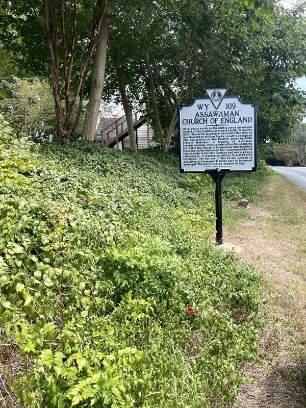
On Adams Crossing Road at US 13, on the right when traveling east on Adams Crossing Road.
Near Market Street at College Avenue, on the right when traveling west.
On Market Street near South Street, on the left when traveling west.
On US 13 at W. Main Street, on the left when traveling north on US 13.
On Market Street, 0.1 miles west of West Street, on the right when traveling west.
On Market Street, 0.1 miles west of Mt. Prospect Avenue, on the left when traveling west.
On County Line Road at County Line Road, on the right when traveling north on County Line Road.
On Bobtown Road Rt 178, 0.2 miles north of St. George Circle, on the right when traveling north.
On St. George Circle just north of Bobtown Road (Virginia Route 178), on the right when traveling west.
On Main Ridge Road near Ponderosa Lane.
On US 13 north of Saxis Road, on the left when traveling north.
Paid Advertisement
Near Saxis Road near VA 699.
Near Saxis Road near VA 699.
On Gordonsville Road (Virginia Route 231) 1.5 miles Virginia Route 640, on the left when traveling north.
On Stony Point Road (Virginia Route 20) just north of Richmond Road (U.S. 250), on the right when traveling north. Reported permanently removed.
Near Monticello Loop north of Thomas Jefferson Parkway (Virginia Route 53), on the left when traveling north.
On Richmond Road (U.S. 250) 0.1 miles west of Louisa Road (Virginia Route 22), on the right when traveling west.
Near Thomas Jefferson Parkway (Virginia Route 53) west of James Monroe Parkway (County Route 795), on the right when traveling east.
Near Monticello Loop north of Thomas Jefferson Parkway (Virginia Route 53), on the left when traveling north.
Near Thomas Jefferson Parkway.
On Ivy Farm Road (County Route 1015), on the left when traveling east.
On Scottsville Road (Virginia Route 20) 0.5 miles south of Frys Path (Virginia Route 627), on the right when traveling north.
On Louisa Road (Virginia Route 22) 0.1 miles west of Whitlock Road (Virginia Route 616), on the left when traveling west.
On Gordonsville Road (Route 231) 0.1 miles south of Millwood Lane (County Road 783), on the left when traveling south.
On Virginia Route 231 north of Lindsay Road, on the left when traveling north.
On Plank Road (County Route 692) at Monacan Trail Road (U.S. 29), on the right when traveling west on Plank Road.
On Richmond Road (U.S. 250) east of Exit 124 (Interstate 64), on the right when traveling east.
Paid Advertisement
On Thomas Jefferson Highway (Virginia Route 53) just east of Milton Road (County Route 732), on the right when traveling east. Reported permanently removed.
Near Brenman Park Drive south of Duke Street (Virginia Route 236), on the left when traveling west.
On Prince Street west of South Union Street, on the right when traveling west.
On Prince Street just west of South Pitt Street, on the right when traveling west.
Near North Lee Street south of Cameron Street, on the left when traveling north.
Near North Union Street east of Fayette Alley, on the right when traveling north. Reported missing.
On Pioneer Mill Way just east of The Strand, in the median.
On King Street (Virginia Route 7) at North West Street, on the right when traveling west on King Street.
On Cameron Street east of North Royal Street, on the right when traveling east.
On North Fairfax Street south of Cameron Street, on the left when traveling south.
On King Street (Virginia Route 7) at North Columbus Street, on the left when traveling east on King Street.
Near Wharf Street east of Ford's Landing Way, on the right when traveling west. Reported unreadable.
On King Street east of Strand Street.
On South Alfred Street at Downham Way, on the right when traveling south on South Alfred Street.
On South Lee Street north of Duke Street, on the right when traveling north.
On King Street near North St Asaph Street, on the right when traveling west.
Paid Advertisement
On Cameron Street just west of North Fairfax Street, on the left when traveling west.
On King Street at North Fairfax Street, on the left when traveling east on King Street.
On Princess Street at North St. Asaph Street, in the median on Princess Street.
On Duke Street east of South Fairfax Street, on the right when traveling east.
On Prince Street west of South Lee Street, on the right when traveling west.
On Prince Street at South Saint Asaph Street, on the right when traveling west on Prince Street.
On South Royal Street at Jones Point Drive, on the left when traveling south on South Royal Street.
On Diagonal Road at King Street (Virginia Route 7), on the left when traveling east on Diagonal Road.
Near North Union Street south of Cameron Street, on the right when traveling north. Reported permanently removed.
On King Street at North Royal Street, on the right when traveling west on King Street.
Near South Street near South Washington Street (Virginia Route 400).
Near Jones Point Drive, 0.2 miles east of South Lee Street, on the right when traveling east.
Near Jones Point Drive, 0.2 miles east of South Royal Street, on the right when traveling east.
On South Fairfax Street south of Prince Street, on the right when traveling north.
On King Street at Strand Street, on the left when traveling west on King Street.
Paid Advertisement
On Cameron Street west of North Lee Street, on the right when traveling west.
On North Fairfax Street south of Cameron Street, on the left when traveling south.
Near North Fairfax Street north of King Street, on the right when traveling north. Reported permanently removed.
Near Jones Point Drive, 0.2 miles South Royal Street, on the right when traveling east.
On North Royal Street at Caneron Street, on the right when traveling south on North Royal Street.
On South Union Street just north of Wales Alley, on the right when traveling north.
Near Jones Point Drive at South Royal Street.
On North Royal Street south of Cameron Street, on the right when traveling south.
On King Street at North Lee Street, on the left when traveling east on King Street.
On King Street at Fairfax Street, on the left when traveling east on King Street.
On King Street east of North Fairfax Street, on the right when traveling west.
Near Jones Point Drive, 0.2 miles east of South Royal Street, on the right when traveling east.
Near Diagonal Road (Virginia Route 7) south of King Street (Virginia Route 7), on the right when traveling south. Reported permanently removed.
Near Cameron Street east of North Union Street, on the right when traveling east. Reported permanently removed.
On Cameron Street near North St. Asaph Street, on the left when traveling west.
Paid Advertisement
On South Pitt Street north of Prince Street, on the right when traveling south.
Near Strand Street just south of Prince Street, on the right when traveling south.
Near The Strand at King Street, on the right when traveling north.
On North Columbus Street at Cameron Street on North Columbus Street. Reported permanently removed.
On Princess Street at North Washington Street, in the median on Princess Street.
On Mount Vernon Avenue at East Oxford Avenue, on the right when traveling south on Mount Vernon Avenue.
On Potomac Avenue north of East Glebe Road, on the right when traveling north.
On Payne Street at Wilkes Street, on the right when traveling north on Payne Street.
Near Francis Hammond Parkway, 0.2 miles east of Key Drive, on the right when traveling east.
On Chinquapin Drive, 0.1 miles south of King Street (Virginia Route 7), on the right when traveling north.
On Business Center Drive south of Witter Drive, on the left when traveling north.
On Interstate 64, 0.6 miles east of Jerry's Run Road (Virginia Route 198), on the right when traveling east.
On U.S. 220, 2.7 miles south of County Route 606, on the right when traveling north.
On Holly Farms Road (Route 307) west of Thompson Lane, on the right when traveling west.
On South Amherst Highway (U.S. 29) south of North Coolwell Road (County Route 663), on the right when traveling south.
Near Horseshoe Road (County Road 656) 0.1 miles north of Burge Road, on the right when traveling south.
Paid Advertisement
On Columbia Pike (Virginia Route 244) just east of South Four Mile Run Drive.
On North Glebe Road (Virginia Route 120) just north of Fairfax Drive (Virginia Route 237), on the left when traveling north.
Near Sherman Drive, 0.2 miles south of Lincoln Drive, on the left when traveling south.
Near Sherman Road, 0.2 miles south of Lincoln Drive, on the left when traveling south. Reported missing.
1655 entries matched your criteria. The first 100 are listed above.
Next 100 ⊳