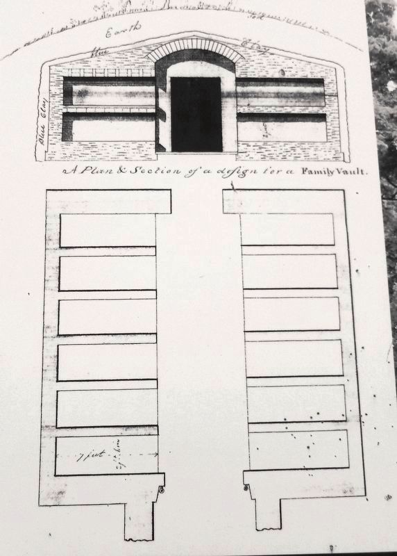
Marker detail: Family vault sketch
| On Livingston Avenue east of North Swan Street/Colonie Street, on the right when traveling east. |
| On Eagle Street at Eagle Street and State Street, on the right on Eagle Street. |
| On Brandle Road, 0.1 miles south of Main Street (New York State Route 146), on the left when traveling south. |
| On Loudon Road (U.S. 9), on the left when traveling north. |
| Near Delaware Avenue, on the right when traveling south. |
| On Heritage Lane, 0.1 miles east of Airline Drive, on the right when traveling west. |
| On Western Avenue (U.S. 20) 1 mile west of Fuller Station Road, on the right when traveling east. |
| On Brandle Road, 0.6 miles north of Altamont-Voorheesville Road (New York State Route 156), on the right when traveling north. |
| On Altamont-Voorheesville Road (New York State Route 156) near Brandle Road, on the right when traveling south. |
| On New York State Route 146, on the left when traveling west. |
| On Menand Road (New York State Route 378) at Van Rensselaer Blvd, on the right when traveling west on Menand Road. |
| On New Scotland Road (New York State Route 85) at Couse Lane, on the right when traveling south on New Scotland Road. |
| On Fisher Boulevard, on the right when traveling north. |
| On Vista Boulevard west of New York State Route 85 when traveling west. |
| On Bridge Street (New York State Route 396), on the right when traveling west. |
| On New York State Route 417, on the right when traveling west. |
| On East Main Street, 0.2 miles east of Peacock Hill Road, on the right when traveling west. |
| Near Main Street (New York State Route 120) at Bartlett Road, on the right when traveling north. |
| On Medbury Ave, on the left when traveling east. |
| On Genesee St at Willard Ave., on the left when traveling north on Genesee St. |
| On St Ann's Avenue, on the right when traveling south. |
| On Ravine Avenue, on the left when traveling south. |
| On Vestal Street at South Street, on the right when traveling south on Vestal Street. |
| On Main Street south of Charles Street, on the left when traveling north. |
| On U.S. 11 at Collins Street, on the right when traveling south on U.S. 11. |
| On Church Road, 0.1 miles south of Cherry Valley Road, on the right when traveling south. |
| On Jefferson Street (U.S. 219) 0.2 miles south of Martha Street, on the left when traveling south. |
| On Cadiz Road (County Route 69) 0.2 miles south of Salamanca Sugartown Road (New York State Route 98), on the left when traveling south. |
| On Broadway Road (County Route 4) 0.2 miles north of Point Peter Road, on the left when traveling south. |
| On Portville-Obi Rd (New York State Route 305) at Temple St, on the right when traveling south on Portville-Obi Rd. |
| On Genesee Street at Fort Street, on the right when traveling east on Genesee Street. |
| On State Street (New York State Route 38) 0.2 miles north of York Street, on the left when traveling south. |
| On Fort Street at Westlake Avenue, on the right when traveling south on Fort Street. |
| On North Street (New York State Route 34) at Carpenter Street, on the right when traveling north on North Street. |
| On North State Road (New York State Route 34 at milepost 30.5), 0.2 miles south of Downs Road, on the left when traveling south. |
| On Main Street (New York State Route 370) 1 mile east of North Street (New York State Route 34), on the left when traveling east. |
| On West Hill Road west of Main Street (New York State Route 38), on the left when traveling west. |
| On New York State Route 104 west of Queens Farm Road, on the left when traveling east. |
| On New York State Route 90, 0.1 miles north of Erie Street, on the left when traveling north. |
| On New York 104A, on the left when traveling west. |
| On New York State Route 90 at Dresser Road on State Route 90. |
| On South Seneca Street (New York State Route 34) at Highland Avenue, on the right when traveling north on South Seneca Street. |
| On East Main Street (U.S. 20). |
| On Lakeview Avenue just south of Buffalo Street, on the left when traveling south. |
| Near Lakeview Avenue at Buffalo Street. |
| On Lakeview Avenue north of Buffalo Street, on the right when traveling north. |
| On West 4th Street at Clinton Street, on the right when traveling west on West 4th Street. |
| Near Lakeview Avenue at Buffalo Street. |
| On Main Street east of Miller Street, on the left when traveling east. |
| On Main Street east of Miller Street, on the left when traveling east. |
| Near Davis Street, on the right when traveling south. |
| On Davis Street just south of Woodlawn Avenue, on the right when traveling north. |
| On Davis Street at Woodlawn Avenue, on the right on Davis Street. |
| On Oneida Road (County Road 60) at Cemetery Road, on the right when traveling west on Oneida Road. |
| On West 2nd Street at College Avenue, on the right when traveling west on West 2nd Street. |
| On Walnut Street, on the left when traveling north. |
| On Walnut Street, on the left when traveling north. |
| On New York State Route 60, 0.2 miles west of Williams Road, on the right when traveling east. |
| On Oneida Road (County Road 60), on the right when traveling west. |
| On Oneida Road (County Road 60), on the right when traveling west. |
| On 1400 Maple Street north of New York State Route 427. |
| On East Main Street, on the right when traveling north. |
| On New York State Route 41 at New York State Route 206 on State Route 41. |
| On Indian Brook Road, on the right when traveling north. |
| On County Route 36, 0.3 miles north of County Route 35, on the left when traveling north. |
| On New York State Route 8. |
| On New York State Route 12. |
| On Hoben Road, on the left when traveling west. |
| On New York State Route 12, on the right when traveling north. |
| On New York State Route 26 north of Hakes Calhoun Road, on the right when traveling north. |
| On NY State Route 8 at White Store Road, on the left when traveling north on NY State Route 8. |
| On Union Road (County Route 39) at Brown Road, on the right when traveling north on Union Road. |
| On Oak Street, on the left when traveling north. |
| On New York State Route 9 north of Duprey Road, on the left when traveling north. |
| On Ashley Road north of New York State Route 22, on the right when traveling north. |
| On Main Street, on the right when traveling west. |
| On New York State Route 22B, 0.1 miles south of Broadwell Road, on the right when traveling south. |
| On Cumberland Head Road, on the left when traveling east. |
| On U.S. 9 just south of Lake Forest Drive, on the left when traveling south. |
| On New York State Route 9 south of Prairie Lane, on the right when traveling south. |
| On New York State Route 295, 1 mile west of New York State Route 22, on the right when traveling west. |
| On County Route 9, 0.2 miles north of New Concord Road, on the right when traveling north. |
| On Albany Avenue (County Route 21), on the right when traveling west. |
| On Wire Road at County Route 10, on the left when traveling south on Wire Road. |
| On County Route 7, 0.2 miles east of MacNeil Road, on the right when traveling west. |
| On County Route 13, 0.2 miles south of Ford Road, on the left when traveling north. |
| On Silvernails Road (County Route 7) 0.1 miles Gallatinville Road, on the left when traveling north. |
761 entries matched your criteria. The first 100 are listed above.
Next 100 ⊳