On Rock Creek and Potomac Parkway Northwest, 0.1 miles south of Virginia Avenue Northwest, on the right when traveling south.
For years it was a dream – a canal to open a trade route from local commercial centers to the rich Ohio country across the Allegheny Mountains. Business would thrive as mule-drawn barges carried wheat, furs, whiskey, livestock, and coal to . . . — — Map (db m46939) HM
Near L Street Northwest west of 26th Street Northwest, on the left when traveling west.
These kilns were used as late as 1908, supplying Washington with a fine grade of lime. The limestone was brought from quarries just beyond Seneca, Maryland over the C & O Canal. — — Map (db m136875) HM
On Rock Creek Trail Northwest, 0.2 miles south of Virginia Avenue Northwest, on the right when traveling south.
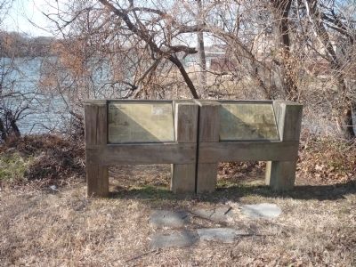
The Potomac River and nearby Rock Creek meet quietly here at Tide Lock.
Years ago, canal boats locked into Rock Creek from the C&O Canal about a half-mile upstream and then through Tide Lock into the bustling world of the Potomac waterfront. . . . — — Map (db m159241) HM
On Chesapeake and Ohio Canal Towpath at 31st Street Northwest, on the right when traveling west on Chesapeake and Ohio Canal Towpath.
…a long stretch of quiet and peace at the capital’s back door…a wilderness area where we can commune with God and with nature.
…a place for boys and girls, men and women…hike 15 or 20 miles on a Sunday afternoon…sleep on high dry ground in . . . — — Map (db m167593) HM
Near 34th Street Northwest south of M Street Northwest, on the right when traveling south. Reported unreadable.
If you could have walked along the towpath here in the 19th and early 20th century, your senses would have been overwhelmed by industrial pollution. The dust from coal being unloaded from canal boats fogged the air. The stench of animal fat being . . . — — Map (db m113411) HM
On C&O Canal Towpath Northwest west of Thomas Jefferson Street Northwest, on the left when traveling west.
“It shall be their duty, at all hours, by night as well as by day, to pass all boats and floats presenting themselves at their locks.” —Charles Mercer, President, C&O Canal Company.
Every time his boat passed through a lock, a . . . — — Map (db m128) HM
On Grace Street Northwest at Paper Mill Court Northwest, on the right when traveling west on Grace Street Northwest.
The original Canal House was built in 1878 to store the feed and horses of the Georgetown Railroad Company. In the 1890's it was converted into a power generating plant for public transit. Today the Canal House stands as another example of the . . . — — Map (db m121206) HM
On Wisconsin Avenue Northwest at C&O Canal Towpath Northwest, on the right when traveling south on Wisconsin Avenue Northwest.
Chesapeake & Ohio Canal. Commenced at Georgetown. July 4th 1828. Chief Engineer Benjamin Wright.
Chesapeake & Ohio Canal Company, 1850. President James M. Coale. Directors William A. Bradley, Henry Daingerfield, Wm. Cost Johnson, John . . . — — Map (db m118) HM
Near Rock Creek and Potomac Parkway Northwest south of Pennsylvania Avenue Northwest, on the right when traveling south.
One of the best preserved and least altered of old American canals, the Chesapeake and Ohio grew from Washington's vision of linking the valleys of the early west with the east by “ties of communication.”
The Potomac Company . . . — — Map (db m97477) HM
On C&O Canal Towpath Northwest west of Thomas Jefferson Street Northwest, on the left when traveling west.
“It is a refuge, a place of retreat, a long stretch of quiet and peace at the Capital's back door . . .” —William O. Douglas
Look around you. The park you stand in exists because people cared. In January 1954, Justice William O. . . . — — Map (db m129) HM
On M Street Northwest at 34th Street Northwest, on the left when traveling west on M Street Northwest. Reported permanently removed.
Before 1620 the area of the Francis Scott Key Park was inhabited by members of the Algonquian, Nacostine, Nacotchatank, Piscatoway and Patawomeke tribes. In 1634 it became part of the English Colony of Maryland.
Beginning in the 18th . . . — — Map (db m119) HM
Near C&O Canal Towpath Northwest east of Thomas Jefferson Street Northwest, on the left when traveling east.
Left panel: Georgetown became a port city soon after its 1751 founding. Located on the Potomac River, it was the logical choice for the canal’s terminus. Canal activity further spurred Georgetown’s economic growth. By the late 1800s, it was . . . — — Map (db m97762) HM
On Thomas Jefferson Street Northwest south of M Street Northwest, on the left when traveling north.
Mules were the "engines" for the canal boats. Normally, a boat captain had four mules. Two worked while two rested in their stall in the front of the boat. Captains usually cared for their mules as if they were part of the family. In the canal's . . . — — Map (db m113416) HM
On 30th Street Northwest, 0.1 miles south of M Street Northwest, on the right when traveling south.
Built between 1856 and 1866 as a machine shop by William T. Duvall, the Foundry is typical of commercial structures of that period. Duvall purchased the land from Thomas Beall, a grandson of Ninian Beall who was one of Georgetown's first settlers . . . — — Map (db m230153) HM
On 31st Street Northwest at C&O Canal Towpath Northwest, on the left when traveling south on 31st Street Northwest.
The Georgetown House is closely linked with the history of the Chesapeake & Ohio Canal. The building was constructed about 1830 by the Chesapeake & Ohio Canal Co. for use as a storage room. Later it became a tavern but shortly thereafter turned into . . . — — Map (db m111008) HM
On 31st Street Northwest south of M Street Northwest, on the left when traveling north.
Canal Square has seen more than century and a half of change in Georgetown. It is a typical brick and fieldstone industrial structure built to facilitate barge traffic on the Chesapeake and Ohio (C&O) Canal. Necessary for westward expansion, . . . — — Map (db m113418) HM
On M Street Northwest west of 31st Street Northwest, on the right when traveling east.
Canal Square has seen more than a century and a half of change in Georgetown. It is a typical brick and fieldstone industrial structure built to facilitate barge traffic on the Chesapeake & Ohio (C&O) Canal. Necessary for westward expansion, canals . . . — — Map (db m240113) HM
Near Virginia Avenue Northwest just west of Rock Creek and Potomac Parkway Northwest, on the right when traveling west.
The 184.5-mile-long Chesapeake and Ohio Canal begins at the Tide Lock and ends at Cumberland, Maryland. Here canal boats entered the canal to bypass mountains, swift currents, and shallows. Boats exited the Tide Lock into the Potomac River to . . . — — Map (db m144180) HM
On Chesapeake & Ohio Canal Towpath at 30th Street Northwest when traveling west on Chesapeake & Ohio Canal Towpath.
In recognition of Justice William O. Douglas for his contributions toward the establishement of the Chesapeake and Ohio Canal National Historic Park — — Map (db m167622) HM
On Wisconsin Avenue Northwest just south of W Place Northwest, on the right when traveling south.
Holy Trinity Catholic Church established Holy Rood Cemetery as its parish cemetery on high ground above Georgetown in 1832. The cemetery was expanded in 1853 to the 6.5 acres it is today. Originally known as the Upper Graveyard, in 1886 the . . . — — Map (db m155228) HM
On Constitution Avenue Northwest (U.S. 50) at 17th Street Northwest, on the right when traveling east on Constitution Avenue Northwest.
President George Washington commissioned Pierre L'Enfant to design the Capital City in 1790. The L'Enfant Plan included a system of canals to transport heavy goods at a time when roads and streets were few and muddy. The Washington City Canal . . . — — Map (db m211) HM
Near Canal Road Northwest north of Reservoir Road Northwest, on the left when traveling north. Reported permanently removed.
This house witnessed the building of the C&O Canal. Abner Cloud, a miller who had come here from Pennsylvania, built the house in 1801. Cloud's mill was about 200 yards upstream. The basement of the house was used by Cloud to store grain and . . . — — Map (db m722) HM
Near Canal Road Northwest north of Reservoir Road Northwest, on the left when traveling north.
Fishing & Farming on the Potomac
This house witnessed the construction of the C&O Canal. Abner Cloud, born in Chester County, Pennsylvania, built this house in 1801 – 24 years before the creation of the Chesapeake & Ohio Canal Company. He . . . — — Map (db m238285) HM
On Capital Crescent Trail. Reported permanently removed.
Baking bread, frying cornbead and eating "stick to your ribs" oatmeal, all have one thing in common; their ingredients started out at a grist mill. Decades before the sounds of lockhorns and mule hooves clopping by, mills were popping up along . . . — — Map (db m129837) HM
On Capital Crescent Trail (at milepost 9), on the right when traveling east.
Here, in 1876, an engineering marvel was built. The largest incline plane in the world and the first built in the United States, carried canal boats to and from the Potomac River. The incline plane was used to help clear heavy boat traffic in . . . — — Map (db m129838) HM
On Q Street Northwest at MacArthur Boulevard, on the right when traveling west on Q Street Northwest.
MacArthur Boulevard was originally named Conduit Road because it provided access to the aqueduct that carried the District's water supply. After World War II it was renamed in honor of General Douglas MacArthur.
From 1902 to 1962, the . . . — — Map (db m187428) HM
Near Canal Road Northwest north of Reservoir Road Northwest, on the right when traveling south.
The Potowmack Company Outlet at Lock Harbor
You are standing on land that once belonged to the Potowmack Company. Created in 1785, the company aimed to make the Potomac River more navigability for trade by building a five-part . . . — — Map (db m238215) HM
Near Canal Street, 0.1 miles west of Wineow Street.
The Cumberland is a full scale replica canal boat, measuring approximately 93 feet long and 14.5 feet wide. It was constructed in 1976 as a Bicentennial project the C&O Canal of Cumberland, Maryland, Inc. (COCCM), a non-profit organization . . . — — Map (db m140080) HM
Near Canal Street, 0.1 miles west of Wineow Street.
For the Chesapeake and Ohio Canal boatmen and their family or crew, the captain's cabin was their living quarters on the boat. About 10 feet by 14 feet in size, the cabin served as the eating and sleeping area for as few as two and as many as 8-10 . . . — — Map (db m140155) HM
On Washington St., on the left when traveling west.
Many changes have been made to the landscape on which Fort Cumberland stood. The street behind you was cut from the hillside and the earth removed used by the canal company. the bluff to your left in front of the church once extended on a nearly . . . — — Map (db m18757) HM
On W. Harrison Street, on the right when traveling south.
Cumberland, the western terminus of the Chesapeake and Ohio Canal, was the location where the George's Creek coal from western Allegany County was transferred from the short line railroads to canal boats for shipment east. Cumberland was also the . . . — — Map (db m67484) HM
Near Canal Street, 0.1 miles west of Wineow Street.
The Chesapeake and Ohio Canal was planned to link the Potomac River and the Chesapeake Bay with Pittsburgh and the Ohio River Valley. Construction began at Georgetown in 1828; by 1850 only 184 of the 365 miles were complete. Financial . . . — — Map (db m140078) HM
On North Centre Street at Market Street, on the right when traveling west on North Centre Street.
A log chapel dedicated to St. Mary was built on this site in 1791. The first parishioners were mostly English Catholics from Southern Maryland. A brick church replaced the log building in 1939. Cumberland became a major center of transportation and . . . — — Map (db m134394) HM
On Canal Street south of Baltimore Street, on the left when traveling south.
During the Civil War, thousands of United States soldiers were stationed here in Cumberland and Allegany County to guard against raids and incursions by Confederate forces. Located only about 130 miles from the capital at Washington. D.C., and a . . . — — Map (db m1049) HM
On Canal Street, 0.1 miles north of West Harrison Street, on the left when traveling north.
About this sign
The outline drawing above represents the heritage-themed mural to your right. The mural is organized chronologically into sections. Each section is described here, with accompanying historic images..
. . . — — Map (db m140048) HM
In 1860, Cumberland was a small town of 7,302 residents, most of whom lived in the valley of Will’s Creek. The town was an important stop on the Baltimore and Ohio Railroad and the western terminus of the Chesapeake and Ohio Canal. When the Civil . . . — — Map (db m14038) HM
On Prospect Square at Washington Street, on the left when traveling north on Prospect Square.
In 1860, Cumberland was a small town of 7,302 residents, most of whom lived in the valley of Will’s Creek. The town was an important stop on the Baltimore and Ohio Railroad and the western terminus of the Chesapeake and Ohio Canal. When the Civil . . . — — Map (db m17674) HM
On Baltimore Street at Canal Street, on the right when traveling west on Baltimore Street.
Downtown
The Downtown Cumberland Mall is the main shopping and dining district for the city. The brick street is lined with large multi-story commercial buildings, which were built in the late 19th and early 20th centuries. These buildings . . . — — Map (db m139110) HM
On Canal Street just north of West Harrison Street, on the left when traveling north.
Downtown Cumberland
The Flood of March 29, 1924 inflicted almost $5 million worth of destruction in the City of Cumberland. Telephone, telegraph, roads and electric wires were washed away. Though not as bad, another flood occurred on May 12th . . . — — Map (db m139111) HM
On Great Allegheny Passage, 0.1 miles north of Baltimore Street, on the left when traveling north.
In 1749 Christopher Gist, an agent for the Ohio Company, arrived at the junction of the Wills Creek and the North Branch of the Potomac River to erect a trading post. In anticipation of the French and Indian War a fort was constructed in 1754 . . . — — Map (db m139113) HM
Will's Creek Settlement, later known as Cumberland, served as a major gateway for trade, military campaigns against the French, and settlement beyond the mountains in our growing nation. "The New Storehouses" of the Ohio Company were across the . . . — — Map (db m17783) HM
On W. Harrison Street, on the right when traveling south.
Independence Day, July 4th, 1828, would be an important day for Cumberland, Maryland. On that day, far to the east, the Chesapeake and Ohio Canal and the Baltimore and Ohio Railroad both broke ground. The finish line of these companies' race was the . . . — — Map (db m67478) HM
Independence Day, July 4th, 1828, would be an important day for Cumberland, Maryland. On that day, far to the east, the Chesapeake and Ohio Canal and the Baltimore and Ohio Railroad both broke ground. The finish line of these companies' race was the . . . — — Map (db m140083) HM
Near Canal Street, 0.3 miles west of Wineow Street.
Hike and bike from Pittsburgh to the Chesapeake Bay. You are standing on part of the Potomac Heritage National Scenic Trail. Explore the Potomac River, Chesapeake Bay, and the Allegheny Highlands on this trail network that includes both land and . . . — — Map (db m140084) HM
This monument was erected in memory of the Irish laborers who died building the Chesapeake and Ohio Canal and the Baltimore and Ohio Railroad
1828 – 1850 — — Map (db m140190) HM
On W. Harrison Street, on the right when traveling south.
The Chesapeake and Ohio Canal ran from Georgetown in Washington, D.C. (Mile 0) to Cumberland, MD (Mile 184.5), paralleling the Potomac River. Most of the heavy shipping originated from the western terminus at Cumberland. Boatmen carrying coal, . . . — — Map (db m67482) HM
On Baltimore Street at Queen City Drive, on the left when traveling east on Baltimore Street.
In the predawn darkness of February 21, 1865, Confederate Lt. Jesse McNeill and his partisan (guerrilla) rangers rode into Cumberland from the west on this road. Unlike most raiders
who targeted the Baltimore and Ohio Railroad for attack, . . . — — Map (db m155354) HM
Near Old Town Road (State Highway 51), on the right when traveling east.
The Paw Paw Tunnel stands as a monument to the ability and daring of 19th century canal builders. By building the mile-long cut through the mountain, including the 3,118-foot tunnel, the canal avoided six miles of river bends and steep, rocky . . . — — Map (db m25098) HM
Walk in the footsteps of the Irish and German laborers who built the Paw Paw Tunnel. Follow a portion of the access road they travelled to get to labor housing and work camps near the vertical shafts on the top of the mountain. Enjoy Potomac . . . — — Map (db m140024) HM
On Green Spring Rd SE, 0.1 miles south of Opessa St.
The basin before you, above Lock 70, provided a landing for canal boats. A general store was built adjoining the original lockhouse. Across the lock a feed store was built. Boatmen could leave the hustle and bustle of Cumberland and tie up here to . . . — — Map (db m140010) HM
Because so many aqueduct stones were lost over the years, replacement stones were needed for the restoration in 2010-11. Beside this panel are an original stone and a new stone to be seen and touched. Note the tooled finish on the stone faces. . . . — — Map (db m101015) HM
On South Maple Avenue, on the left when traveling west. Reported damaged.
First called Berlin, later Barry, and finally named Brunswick in 1890, the town's fortunes fluctuated with the times. The canal was built here in 1834 and a large gristmill, powered by canal water, was built on the canal across from the towpath. . . . — — Map (db m4333) HM
On Railroad Square, on the right when traveling east.
Union troops pursuing the Confederate army to Virginia after the Battle of Gettysburg in July 1863 crossed the Potomac River here. Called Berlin at the time of the Civil War, this town truly experienced the challenges of life on the border. Both . . . — — Map (db m1863) HM
Today towpath hikers and bikers need a bridge to cross the Catoctin Creek here. Many decades ago canal boats needed a bridge too. The Catoctin Aqueduct, completed in 1834, served the canal until 1924. Imagine the scene here in the late 1800s - . . . — — Map (db m101305) HM
On Chesapeake and Ohio Canal Towpath, 0.3 miles west of South Maple Avenue, on the right when traveling east.
Hike and bike from Pittsburgh to the Chesapeake Bay. You are standing on the part of the Potomac Heritage National Scenic Trail. Explore the Potomac River, Chesapeake Bay, and the Allegheny Highlands on this trail network that includes both land . . . — — Map (db m197955) HM
The Brunswick Railroad Museum and the Chesapeake and Ohio Canal National Historic Park Visitor Center exist side by side today, just as the transportation modes did when first arriving here in 1834. However, the early relationship between canal . . . — — Map (db m60881) HM
The Catoctin Aqueduct, or "Aqueduct No. 3," ranks as one of the premiere stone structures on the C&O Canal. Aqueducts carried the canal's waters over creeks and rivers, allowing boats to float safely above the sometimes turbulent waters below. . . . — — Map (db m101016) HM
Near South Maple Avenue, on the right. Reported damaged.
Canal water was an important ingredient in the production of "C.F. Wenner's Choice Family Flour." Brunswick businessman Charles F. Wenner drew surplus water from the canal near Lock 30 to power the wheels and turbines of his flour mill. Wenner . . . — — Map (db m4334) HM
On Chesapeake and Ohio Canal Towpath, 0.2 miles west of South Maple Avenue, on the left when traveling west.
Things to Know Before You Go
The Brunswick TRACK Trail is 0.8 miles one way (1.6 miles round trip) from this kiosk to milepost 56. The trail follows the path of the original towpath of the Chesapeake and Ohio Canal. Along the . . . — — Map (db m197953) HM
Near Dwight D. Eisenhower Highway (Interstate 70), on the right.
The 184-mile C&O Canal, where mule-drawn barges once lumbered alongside the Potomac River, provides a serene waterway for paddling and a towpath for hiking, biking and horseback riding. — — Map (db m116495) HM
Near Dwight D. Eisenhower Highway (Interstate 70) 2 miles west of Maryland Route 17, on the right when traveling west.
The 184-mile C&O Canal, where mule-drawn barges once lumbered alongside the Potomac River, provides a serene waterway for paddling and a towpath for hiking, biking and horseback riding. — — Map (db m196242) HM
Near Dwight D. Eisenhower Highway (Interstate 70) south of Baltimore National Pike (U.S. 40), on the right when traveling east.
Maryland's Appalachian Region Offers Visitors Natural Splendor And Outdoor Adventure, Plus Countless Opportunities To Explore The Region's Rich Heritage—all Just A Few Miles Off Interstate 70.
Maryland Byways, like the Historic National . . . — — Map (db m116525) HM
Maryland's Appalachian Region Offers Visitors Natural Splendor And Outdoor Adventure, Plus Countless Opportunities To Explore The Region's Rich Heritage—all Just A Few Miles Off Interstate 70.
Maryland Byways, like the Historic National . . . — — Map (db m196240) HM
Lockkeepers were available anytime of the day or night to operate this lock. Tending lock was often a family venture and the canal company preferred family men. Lockkeepers were paid as much as $600 a year, and were provided a lockhouse with a . . . — — Map (db m100999) HM
On Canal Street, on the right when traveling west.
This [railroad] company was met by the most decided and inveterate opposition, on the part of the Chesapeake and Ohio Canal Company. Philip E. Thomas, President, Baltimore and Ohio Railroad Company The proximity of railroad tracks by the . . . — — Map (db m7661) HM
Completed in 1837, Lockhouse 28 stands where fierce competition between the C&O Canal and the B&O Railroad brought both to a standstill. Both sides fought long and hard in the race to reach the Ohio River valley and control mid-Atlantic western . . . — — Map (db m100779) HM
On Clay Street (Maryland Route 28) east of Catoctin Mountain Road (U.S. 15).
The rail line immediately before you served as an important means of supply and communication during the Civil War (the station, and tracks to Washington, D.C., on the southern or right side of the station were built later). Here at Point of Rocks, . . . — — Map (db m744) HM
In 1832, Point of Rocks served as the western terminus for the C&O Canal and the B&O Railroad. This was not deliberate, but the result of competition as the transportation pioneers wrangled in court for rights to the narrow passage between the . . . — — Map (db m59743) HM
On Monroe Street at Clay Street (Maryland Route 28), on the right when traveling south on Monroe Street.
The "Point of Rocks" has long served as a distinguishing landmark along the Potomac River. Native Americans, and later colonial settlers and traders, used the vicinity as a home and transportation corridor. River transportation and improvements . . . — — Map (db m168024) HM
On Clay Street (Maryland Route 28) east of Monroe Street, on the right when traveling east.
The Chesapeake & Ohio Canal was an ambitious project to provide access from the east coast into the rapidly developing western areas of the United States. Construction on the C&O Canal began July 4, 1828. It originated in Georgetown (Washington, . . . — — Map (db m168027) HM
On Clay Street (Maryland Route 28) just east of Commerce Street, on the right when traveling east.
The "Point of Rocks" has long served as a distinguishing natural feature for Native Americans residing and traveling through the region. Until the Treaty of Albany in 1722, including English state representatives and Iroquois Nations, the area . . . — — Map (db m168028) HM
On Commerce Street at Clay Street (Maryland Route 28), on the right when traveling north on Commerce Street.
The B&O rail line served as an important means of supply and communication during the Civil War (the station and tracks to Washington, D.C., on the southern or right side of the station were built later).
At Point of Rocks, the Baltimore & . . . — — Map (db m168030) HM
On Commerce Street, 0.1 miles east of Monroe Street, on the right when traveling east.
The arrival of the B&O Railroad in Point of Rocks would have a major impact on the future development of the town. The first train arrived on April 23, 1832, and Point of Rocks remained the terminus of the Old Main Line for three years. Continued . . . — — Map (db m168032) HM
On Chesapeake and Ohio Canal Towpath, on the right when traveling south.
If you walk down the short path to the water's edge and look upriver to your right, you can see Snake Island in the middle of Little Falls Dam. Just behind the island, hidden underwater, is a fishway—a passage that enables fish to swim beyond . . . — — Map (db m136927) HM
On Chesapeake and Ohio Canal Towpath, on the right when traveling south.
Seven dams and one steam pump were built along the river to funnel water into the canal. In times of drought or low water, usually during the height of summer, river levels dropped dramatically. The canal could not get enough water from the river . . . — — Map (db m136925) HM
From its inception the vision of the C&O Canal has evolved, constantly finding ways to be relevant. Built in 1829, Lockhouse 6 stands a mile upstream from Little Falls, site of the canal's July 4th groundbreaking the previous year. Lockhouse 6 . . . — — Map (db m112119) HM
Near Clara Barton Parkway south of the Glen Echo Exit. Reported permanently removed.
“When I was 7, we moved [to the] lock, and we were very happy. My mother was so happy to have a home; she was just about wild. And we did love it here, as a locktender, you know?” —Lavenia Cross Waskey
On MacArthur Boulevard, on the right when traveling east.
In the late 19th century the scenery and climate were so renowned that people traveled from distant points seeking the serenity and pleasures that Cabin John offered. They came for the fishing and to view the largest stone arch in the world, an . . . — — Map (db m164234) HM
Near Clara Barton Parkway, 1 mile east of Capital Beltway Inner Loop (Interstate 495).
It shall be the duty, at all hours, by night as well as day, to pass all boats and floats presenting themselves at their locks. — Charles Mercer, President, C&O Canal Company
Every time his boat passed through a . . . — — Map (db m103222) HM
On MacArthur Boulevard, on the right when traveling east.
"… in our midst exists one of the most imposing and wonderful structures which engineering skill could devise …"
--William T.S. Curtis, November 1, 1897, from a paper read before the Columbia Historical Society.
As late as the mid-19th . . . — — Map (db m22636) HM
The “drop gate” on this lift lock was a technological advance over the more common swing-gate lock. It was faster and could be more easily operated by a single employee.
Only a few drop-gates were installed on the canal, most of . . . — — Map (db m103200) HM
Near Clara Barton Parkway, 1.5 miles Capital Beltway Inner Loop (Interstate 495), on the right when traveling east.
After being neglected for nearly a decade, the Chesapeake and Ohio Canal received new life with the New Deal programs in the late 1930s. Two African American Civilian Conservation Corps camps were setup at nearby Cabin John and Carderock to . . . — — Map (db m105328) HM
Near Clara Barton Parkway, 2 miles east of Capital Beltway Inner Loop (Interstate 495), on the right.
A long blast on a tin horn followed by the boatman's shout of "Hey-ey-ey! Lock! Aw, Lock!" summoned the lock-keeper to duty. Lock-keepers were hired to "attend constantly and diligently by day and night," during the nine month boating season. They . . . — — Map (db m125189) HM
On Darnestown Road (Maryland Route 28) 0.4 miles west of Seneca Road (Maryland Route 112), on the right when traveling west.
On June 25-27, 1863, the Federal Army of the Potomac used two temporary pontoon bridges to cross the Potomac River from Virginia back into Maryland at Edwards Ferry. On the evening and morning of June 27-28, Confederate Gen. J.E.B. Stuart led 5,000 . . . — — Map (db m1684) HM
Near Darnestown Road (Maryland Route 28) at Seneca Road (Route 112), on the right when traveling west.
By the summer of 1861, the Union recognized Darnestown as an ideal location for establishing a major division headquarters. The town was strategically situated at the intersection of roads leading to the Chesapeake and Ohio Canal and to Washington, . . . — — Map (db m69731) HM
Near Darnestown Road (Route 28) just east of Seneca Road (Route 112), on the left when traveling east.
Darnestown Road is one of the oldest roads in Montgomery County. Once an old trail, the route dates back to 1600 when it was used by the Seneca Indians. Native Americans Established villages, planted maize, and fished along the Potomac Palisades. . . . — — Map (db m69645) HM
On Whites Ferry Road (Maryland Route 107) at River Road, on the left when traveling west on Whites Ferry Road.
Chesapeake & Ohio Canal National Historical Park. The canal and towpath are dedicated to Justice William O. Douglas of White Ferry. — — Map (db m810) HM
On Dickerson Road (Maryland Route 28) at Mouth of the Monocacy Road, on the left when traveling north on Dickerson Road.
Largest of eleven C&O aqueducts. Finished 1833, Alfred Cruger, Principal Engineer. Constructed of quartzite from Sugarloaf Mountain. It served until 1924, when after a flood, commercial operations ceased.
Administered by the National . . . — — Map (db m15016) HM
Near Mouth of Monocacy Road at Dickerson Road (Maryland Route 28).
Confederate Gen. D. H. Hill’s division crossed the Potomac at Point of Rocks on September 4, 1862, and marched south to clear Union forces from the area. His men breached and drained the Chesapeake and Ohio Canal at several places, burned canal . . . — — Map (db m65210) HM
On Mouth of Monocacy Road, 1.3 miles west of Dickerson Road (Maryland Route 28), on the right when traveling west.
Springing Over the Monocacy
Captain William McNeill of the U.S. Topographical Engineers called this aqueduct “...a work which, while it is highly ornamental, unites...in its plan and execution, ‘the true principles of economy, . . . — — Map (db m714) HM
Near Whites Ferry Road (Maryland Route 107) at River Road.
Before you is the last operating ferry on the Potomac River. Early settlers recognized these relatively still waters would provide an ideal location for a ferry. The first known ferry operation here was Conrad’s Ferry in 1817. After the Civil War, . . . — — Map (db m741) HM
Near Whites Ferry Road, 0.1 miles south of River Road, on the right when traveling west.
The serenity of the Maryland countryside was
shattered on September 4-6, 1862, as 35,000 Confederate soldiers of the Army of Northern Virginia
waded across the Potomac River. Gen. Robert E. Lee, hoping to rally support in the divided
state, sent . . . — — Map (db m173131) HM
Near Martinsburg Road, 2.5 miles west of Darnestown Road (Maryland Route 28), on the right when traveling west. Reported permanently removed.
A wing of Gen. Robert E. Lee’s Army of Northern Virginia commanded by Gen. James Longstreet, as well as part of Gen. J.E.B. Stuart’s cavalry, crossed into Maryland just south of here on September 5-6, 1862. Other parts of the 40,000-man force, . . . — — Map (db m812) HM
Near Martinsburg Road, on the right when traveling south.
During the Civil War, White's Ford on the Potomac River was employed by Confederate troops on three separate occasions. Lee's troops crossed here in their invasion of Maryland, September 4-7, 1862. General Jubal A. Early's II Corps, after an . . . — — Map (db m10145) HM
Near Martinsburg Road, 1.2 miles west of Wasche Road, on the right when traveling west.
After Confederate Gen. Robert E. Lee's smashing victory over Union Gen. John Pope at the Second Battle of Manassas, Lee decided to invade Maryland to reap the fall harvest, gain Confederate recruits, earn foreign recognition of the . . . — — Map (db m237612) HM
The Potomac River is calm and narrow here, making it an ideal location for a ferry crossing. In 1791 Edwards Ferry began to operate here, connecting Maryland farmers to the Goose Creek Canal in Virginia and to the Leesburg markets. The ferry closed . . . — — Map (db m78350) HM
On Edwards Ferry Road, 0.1 miles west of River Road, on the right when traveling west.
In the mid-nineteenth century, Lockhouse 25 and the surrounding community of Edwards Ferry, Maryland, reaped the advantages of their locations. With the nearby river lock, the area served as the bustling entry point to the C&O Canal for agricultural . . . — — Map (db m78348) HM
Gen. Joseph Hooker’s 75,000-man, seven-corps Army of the Potomac crossed the Potomac River here, June 25-27, 1863, on the way to Gettysburg. The army crossed on two 1,400-foot-long pontoon bridges. Heavy rains during those three days made the . . . — — Map (db m33741) HM
On Chesapeake and Ohio Canal Towpath, on the left when traveling north.
Canal engineers encountered many problems, but perhaps the most perplexing was navigating around the Great Falls of the Potomac.
At Widewater the canal builders used a river channel abandoned thousands of years ago by the Potomac when it cut its . . . — — Map (db m164457) HM
185 entries matched your criteria. The first 100 are listed above. The final 85 ⊳