On East Red Bridge Road, on the right when traveling west.
(This marker has two panels. From the left panel:)
Key Map
Traveling across this bridge, the fourth Red Bridge near this location since 1859, you may notice art panels attached to each of the large pillars that rise at both . . . — — Map (db m210568) HM
On East 99th Street east of Holmes Road, on the right when traveling west.
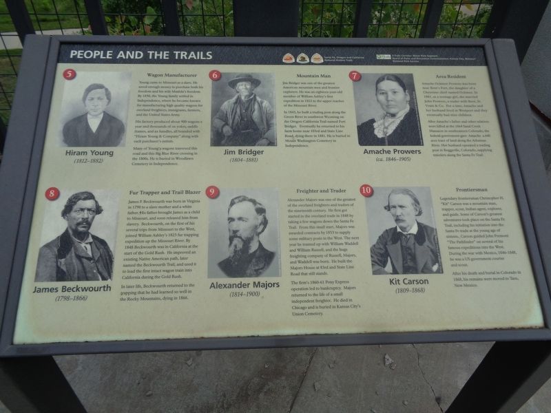
Public/private partnerships preserve three National Historic Trails in south Kansas City, highlighting 19th century exploration and migration that shaped the nation. In the heart of the historic 3-Trails Corridor, the Trailside Center at East 99th . . . — — Map (db m199522) HM
On Lincoln Avenue at High Street, on the right when traveling west on Lincoln Avenue.
In this two room school from 1888 to 1960 dedicated teachers provided an elementary education to more than 3,000 black children of our community. — — Map (db m248689) HM
On South 4th Street west of South Adams Street, on the right when traveling east.
This site was home of the Douglass Cooperative High School from 1939-1955, which is an important part of Festus history. Formed in 1939 under the leadership of Dr. Arthur Shropshire, Douglass School served as the only high school for black students . . . — — Map (db m248690) HM
On Valles Mines School Road, 0.6 miles south of State Highway V, on the right when traveling north.
Built around 1840 and said to have been a slave cabin used by a previous owner on a farm in Valle Mines (St. Francois County). Around 1870, Salim Grandjean, a Swiss immigrant, gold miner and wagon maker, purchased the farm from his uncle and . . . — — Map (db m229208) HM
This sculpture, honoring John William "Blind" Boone was commissioned by the Blind Boone Renovation Group & created in honor of Mr. Boone by artist Ai Qiu Hopen. It sits on a piece of locally quarried limestone. Volunteers raised the money for the . . . — — Map (db m85381) HM
Originally built in 1954 as a segregated park with only restrooms & two BBQ grills, the park has experienced a rebirth as over 3,000 volunteers and many generous donors contributed to the 2000 - 2005 rebuilding of this 3.28 acre site & its . . . — — Map (db m85378) HM
On Green Street at South 3rd Street, on the right when traveling east on Green Street.
Lincoln School was established in 1880 to provide education for African-American children in the Canton area. It served that purpose until 1955. One of a handful of red brick school houses of it's kind, it remains as a tribute to rural education in . . . — — Map (db m55406) HM
On Pershing Drive north of Front Street, on the left when traveling north.
Laclede, Mo. was established in 1853. Conveniently located with access from the railroads, Laclede was at one time quite a prosperous town. general stores, banks, factory work, appliance retail, implement dealerships, upholstery, beauticians, . . . — — Map (db m67078) HM
Career Strike Outs of St. Louis Cardinal pitcher Bob Gibson. Dominating and intimidating on the mound, Gibson won 251 games during his career, 56 by shutout. His best season was 1968, when he went 22-9 with a 1.12 Earned Run Average and 13 Shutouts. . . . — — Map (db m156629) HM
On Hill Street at 9th Street, on the left when traveling west on Hill Street.
"I am not Injun Joe"
As a young boy, Joe was found scalped and left for dead in Oklahoma by a man named Douglas who brought him to Hannibal. He lived on this site in the 1840's when he worked as a roustabout on the river . . . — — Map (db m156602) HM
On U.S. 60, on the left when traveling east. Reported permanently removed.
Rev. Owen Whitfield with the support of local landowner, Mr. Thad Snow, and 1500 black and white sharecroppers camped here in harsh January weather several days in 1939 to protest the plight of Boot Heel sharecroppers. The event received national . . . — — Map (db m77862) HM
One wintry morning in January 1939, residents of Southeast Missouri woke to find two thousand black & white sharecroppers alongside two state highways. With them were their families and the few meager belongings that they owned.
The . . . — — Map (db m216652) HM
On U.S. 50 west of Walnut Street, on the left when traveling west.
[Front]
Historic town in the annals of western transportation, Tipton, in 1858-59, was the eastern stagecoach terminus of the famous Butterfield Overland Mail. N.Y. expressman John Butterfield (1801-69), under contract to carry mail and . . . — — Map (db m62481) HM
The cabin site offers an impression of the slave cabin in which Carver was born. Its mysteries reflect the confused circumstances of Carver's early life.
The log cabin in which George Washington Carver was born was not built with the . . . — — Map (db m42011) HM
Right Road
…how can I be sure that I’m on the right road?… “In all thy ways acknowledge Him, and He shall direct thy paths.” Now you must learn to look to Him for direction and then follow, and you will never go wrong.
George . . . — — Map (db m42892) HM
This spring was the closest drinking water for the Carver household in the 1860s. Accoring to George, he was too frail for field work. His guardian, Susan Carver, gave him many household chores including drawing water from this spring. As a typical . . . — — Map (db m42030) HM
The farm on which George Washington Carver grew up was owned by Moses and Susan Carver. While George’s path in life took him far from here, he considered this farm his first home.
In the 1830s, Moses and Susan Carver moved from Sangamon . . . — — Map (db m42007) HM
George, like most children, was supposed to stay in after dark. He later recalled, "...my brother and I would sometimes steal out to the persimmon tree. And when we went into the house there was Mrs. Carver waiting for us beside a jar of willow . . . — — Map (db m42032) HM
Sometime near the end of the Civil War, a slave was born here in a cabin. His mother, Mary, named the baby - her second son - George. Moses Carver had purchased Mary as an enslaved person back in 1855, when she was about 13 years old.
Years of . . . — — Map (db m42028) HM
William Williams married Moses Carver's niece, Sarah Jane Carver, in 1853 and they built their home beside this spring. Their two children, Daniel and Martha, played with George Washington Carver as they grew up on the farm.
During the 1930's . . . — — Map (db m42031) HM
On Spring Street near Spring Hill Street, on the right when traveling west.
A former slave boy, George Washington Carver came to Neosho in the 1870s seeking an education. At Neosho’s Lincoln School, he began his long climb out of ignorance. This was his first step toward becoming a world-famous scientist and teacher at . . . — — Map (db m43025) HM
On Main Street at Lamine Avenue, on the left when traveling east on Main Street.
A tribute to the living legacy of
Scott Joplin
and to Sedalia, "The Cradle of Ragtime"
Dedicated
June 1, 1999
——————————
[Wayside Interpretive Panel]
1st Page of the . . . — — Map (db m85294) HM
On Main Street at Lamine Avenue, on the left when traveling east on Main Street.
Erected in tribute to
Scott Joplin
1868 - 1917
Composer
John Stark
1841 - 1927
Publisher of
The Maple Leaf Rag
and
other Sedalia Ragtimers
Arthur Marshall
Scott Hayden . . . — — Map (db m85277) HM
On East 5th Street just east of South Ohio Avenue (State Highway 750), on the right when traveling east.
On this site, August 10, 1899 Scott Joplin signed the contract for John Stark to publish The Maple Leaf Rag Joplin almost immediately gained fame as the King of Ragtime and the famous royalty contract enabled . . . — — Map (db m216896) HM
On West 9th Street just east of North Pine Street, on the right when traveling east.
"The USO had a substantial operation in Rolla during World War Two, serving thousands of soldiers on leave looking for recreation and an opportunity to get away from military life at Fort "Lost-in-the-Woods". The need for appropriate, and . . . — — Map (db m186162) HM
On Bardsley Road south of Arkansas Avenue, on the right when traveling south.
This passenger car was built in 1883 by the Barney & Smith Car Company from Dayton, Ohio. The Barney & Smith Company built premier railroad passenger cars from 1848 to about 1894 and electric trolley cars for the next 20 years. The company had . . . — — Map (db m157186) HM
New Orleans may be known as the birthplace of jazz, but “America’s music” really grew up in Kansas City. Here, jazz developed and matured, growing out of ragtime and blues into a distinct Midwestern sound. The most important bands to . . . — — Map (db m43224) HM
On a warm summer evening in Kansas City, you can develop an appetite just driving down the street. That’s because this unofficial “Home of Barbecue” boasts more than 90 barbecue-devoted restaurants, as well as numerous BBQ cookoffs, and . . . — — Map (db m43194) HM
To many fans outside of K.C., it might seem as if the birth of baseball here began when Ewing Kauffman founded the Kansas City Royals in 1969, and gave the town the beautiful, now-named Kauffman Stadium in 1973. And it might seem as if our most . . . — — Map (db m196103) HM
He wasn’t born in Kansas City, but in his heart, Satchel Paige called it home. As a pitcher for the Kansas City Monarchs and six other teams, Satchel Paige was the nearest thing to a legend that ever came out of the Negro Leagues. His fastball and . . . — — Map (db m43183) HM
In the 1850s, one-third of Weston’s population was African-American. As you look down this hillside and up towards the back fence of the cemetery, you see the area that was set aside for those individuals, free or slave, of African-American . . . — — Map (db m77295) HM
Father Augustine Tolton was born of slave parents April 1, 1854 at Brush Creek, Ralls County, Missouri, and was baptized by Father John O'Sullivan in St. Peter's Catholic Church, Brush Creek, May 29, 1854.
Educated in Quincy, Illinois, he was . . . — — Map (db m244310) HM
The 1860 census shows 15,000 people living in Saline county, 5,000 of whom were enslaved African Americans. The collapse of the hemp market and emancipation in 1865 resulted in many African Americans leaving farms and plantations. Many "freedmen" . . . — — Map (db m247019) HM
This cemetery has existed since at least 1856. At first set aside as a burial ground for enslaved individuals, members of the Arrow Rock African American community continued to use it after emancipation in 1865 and into the 21st century. The . . . — — Map (db m247026) HM
On Missouri Route AA north of County Route 216, on the right when traveling south.
Oral tradition says that prior to 1856, Dr. John Sappington, pioneer Arrow Rock physician, gave approximately two acres of land to Emanuel Banks, a long time and highly regarded servant, to be used as a cemetery.
Since the mid-nineteenth . . . — — Map (db m247027) HM
This cemetery has served the African American community of Arrow Rock for more than 150 years. Most communities in Missouri had designated cemeteries for African American burials, continuing the practice of segregation. In oral history passed down . . . — — Map (db m247020) HM
On South Main Street north of Madison Street, on the left when traveling north.
"The first term of the Court of Common Pleas in and for the District of St. Charles was held on the first Tuesday in January, 1805, in the house of Dr. Antoine Reynal on the site of the present courthouse." The "present" courthouse of . . . — — Map (db m124826) HM
On North Main Street at Clark Street, on the left when traveling north on North Main Street.
During Prohibition, Moses Bowlen O'Bannon rented the two-story brick Green Tree Tavern from former brewer Charles Schibi. O'Bannon sold soft drinks and had a license to operate two billiard tables from 1921 until 1930. O'Bannon born in 1873, the son . . . — — Map (db m124883) HM
Slave and free Africans migrated to St. Charles through the "underground railroad" by word of mouth from storytellers, which was a great art among Africans because they were descendants of different tribes, speaking different dialects. They brought . . . — — Map (db m163860) HM
On South Main Street north of Perry Street, on the right when traveling south.
Oldest existing brick church north of the Missouri River. Built of hand-made bricks with walls 18 inches thick.
Records establish that Mrs. Catherine Collier built this church in 1831. It was used by her Methodist Episcopal Congregation . . . — — Map (db m124887) HM
Near South Riverside Drive at Madison Street, on the right when traveling north.
On Aug. 10, 1821, Missouri became the 24th state of the United States. Peck Row in St. Charles served as the temporary capitol of Missouri for just over five years, from 1821 to 1826. The promise of free rent, spacious accommodations, close . . . — — Map (db m169206) HM
On North 2nd Street (State Highway 94) just north of Wilkinson Street, on the right when traveling north.
North 2nd Street Shops
North Second Street was a bustling thriving commercial district. Butchers, bakers, tinsmiths and saddle makers all had shops on the street; many lived above them on the second floor. Farmers brought their grain to the . . . — — Map (db m150983) HM
Haitian Negro Fur Trader
First Permanent Chicago Settler
DuSable died 28 Aug 1818, St. Charles Missouri and was buried in the original St. Charles Borromeo Cemetery. According to tradition, his remains were moved to the second Borromeo . . . — — Map (db m182847) HM
On North 2nd Street (State Highway 94) north of Decatur Street, on the right when traveling south.
Upon this property resided Jean Baptiste Point DuSable (1740's-1818) Monsieur DuSable, an African American, is considered to be the "founding father" of Chicago. In 1800 he moved to St. Charles and worked as a fur trader until his death. . . . — — Map (db m162674) HM
American Patriot
Wife of Dred Scott
Mother of Eliza and Lizzy
Co-Plaintiff in the historic
Dred Scott Case
Your plea for equality was raised in obscurity, but in time it became the rallying cry of a people determined to abolish . . . — — Map (db m61991) HM
On DeMenil Place south of Utah Street, on the left when traveling north.
Creole Geminien Beauvais built the largest house in this elegant enclave on this site in the early 1870s.
As a teenager, Beauvais had worked in the lucrative fur trade, a source of seed money for many early 19th century entrepreneurs. . . . — — Map (db m133132) HM
[Front]
Freed from slavery by his friend Taylor Blow.
[Back]
Subject of the decision of the Supreme Court of the United States in 1857 which denied citizenship to the Negro, voided the Missouri Compromise Act, became one of the events that . . . — — Map (db m61970) HM
On North Broadway just east of Convention Plaza, on the left when traveling south.
A Workforce Diversity Program was developed with the Coalition of Black Trade Unionists to promote the employment of female and minority workers on the project.
Negotiations were begun to relocate the National Football League Los Angeles Rams . . . — — Map (db m141884) HM
On South Broadway south of Clark Avenue, on the right when traveling south.
Lou Brock earned the 3,000th hit of his career with a single off Dennis Lamp of the Chicago Cubs at Busch Stadium. The Cubs were the team that originally traded Brock to the Cardinals in 1964. — — Map (db m133397) HM
On South Broadway south of Clark Avenue, on the right when traveling south.
Bob Gibson won his 7th consecutive World Series game, a streak that started in Game One of the 1964 World Series. He soundly defeated the Detroit Tigers in Game Four by a score of 10-1 but his streak ended when he was defeated in Game Seven 4-1, by . . . — — Map (db m133385) HM
On South Broadway south of Spruce Street, on the right when traveling south.
President Barack Obama threw out the first pitch before the American League defeated the National League 4-3, Tampa Bay's Carl Crawford won MVP honors after his leaping catch over the wall made the difference in the game. — — Map (db m151825) HM
On South 8th Street south of Clark Avenue, on the right when traveling north.
Tom Alston became the first black player for the Cardinals, following in the footsteps of the Brooklyn Dodgers' Jackie Robinson, who broke the Major League Baseball color barrier in 1947 after he was signed by former Cardinals General Manager Branch . . . — — Map (db m133342) HM
On South Broadway south of Spruce Street, on the right when traveling south.
Albert Pujols captured his second NL MVP in as many years, making him the first player in team history to receive the honor in back-to-back seasons. Pujols' 2009 honor was the third of his career, tying the franchise mark set by Stan Musial. — — Map (db m151824) HM
On South Broadway south of Spruce Street, on the right when traveling south.
Mark McGwire hit the longest home run at Busch Stadium (1966-2005) a 545 ft. blast off the Marlins' Livan Hernandez. It was hit to dead center field and struck the St. Louis Post-Dispatch sign, which was marked with a large bandage for the rest of . . . — — Map (db m133421) HM
On South Broadway south of Clark Avenue, on the right when traveling south.
Lou Brock broke the Major League Baseball record for stolen bases in a career, held by Ty Cobb, with his 893rd stolen base at San Diego. — — Map (db m133394) HM
On South Broadway south of Clark Avenue, on the right when traveling south.
The Cardinals played their first game at Busch Memorial Stadium before a crowd of 46,048. Lou Brock's bases loaded single in the 12th inning scored the winning run in a 4-3 win over the Atlanta Braves. — — Map (db m133369) HM
On North 4th Street near Market Street, on the left when traveling north.
Dred and Harriet Scott filed suit for their freedom at this courthouse in 1846. Their case reached the United States Supreme Court and was decided in 1857. The court ruled that the Scotts and all African Americans were not citizen of the United . . . — — Map (db m78845) HM
On South Broadway at Cerre Street, on the right when traveling south on South Broadway.
Home of Roswell Field, attorney in the pivotal Dred Scott freedom suit,
has been designated a
National Historic Landmark
This site possesses national significance in commemorating the history of the United States of America
. . . — — Map (db m122223) HM
Near North Broadway at Chestnut Street, on the right when traveling south.
Frankie Muse Freeman, a life member of the NAACP, began her legal career in St. Louis in 1949. In 1954, Freeman served as lead attorney in the landmark NAACP suit against the St. Louis Housing Authority which ended segregation in public housing. In . . . — — Map (db m217222) HM
In 1854 Dred Scott, his wife Harriet, and a group of lawyers stood before the federal court here in St. Louis. The court rejected their claim for freedom. Four years earlier, Dred and Harriet sued for their freedom at the Old Courthouse and won, . . . — — Map (db m236971) HM
On South Broadway, on the right when traveling east.
Ozzie Smith socked the first left handed home run of his career off Tom Niedenfuer of the Los Angeles Dodgers in the ninth inning to give the Cardinals a 3-2 win in Game 5 of the NLCS, prompting broadcaster Jack Buck to exclaim, "Go Crazy, Folks! Go . . . — — Map (db m154064) HM
On South Broadway south of Spruce Street, on the right when traveling south.
In a game against the Cincinnati Reds, Mark Whiten became the first Cardinals player to hit four home runs in one game. Whiten also collected 12 runs batted in which tied Jim Bottomley's franchise record originally set in 1924. — — Map (db m133417) HM
On South 8th Street at Clark Avenue, on the right when traveling north on South 8th Street.
Combined speed, daring and battling skill to rank among best players in Negro Leagues. Contemporaries rated him fastest man on base paths. Hit over .300 regularly, topping .400 on occasion. Played 29 summers and 21 winters of professional baseball. . . . — — Map (db m133359) HM
On South 8th Street at Clark Avenue, on the right when traveling north on South 8th Street.
Baseball's all-time leader in stolen bases with 938. Set Major League record by stealing over 50 bases 12 times and N.L. record with 118 steals in 1974. Led N.L. in stolen bases 8 times. Collected 3,023 hits during 19 year career and holds World . . . — — Map (db m196689) HM
On North 11th Street near Market Street, on the left when traveling north.
For more than two hundred years before the civil war, slavery was legal in North America. White citizens could legally "own" Black Africans who had been captured in Africa and could keep them in permanent, involuntary servitude, under this . . . — — Map (db m237263) HM
On South Broadway south of Clark Avenue, on the right when traveling south.
Bob Gibson no-hit the Pirates with an 11-0 win at Pittsburgh. Jose Cruz' outstanding running catch of Milt May's 400 ft. drive to center field in the seventh, and Joe Torre's leaping grab at third off Dave Cash's grounder in the eighth helped . . . — — Map (db m133389) HM
On South 8th Street at Clark Avenue, on the right when traveling north on South 8th Street.
San Diego, N.L., 1978-1981
St. Louis, N.L., 1982-1996
Revolutionized defensive play at shortstop with his acrobatic fielding and artistic turning of double plays. The 13-time Gold Glove winner set six major league fielding records among . . . — — Map (db m133353) HM
On South Broadway south of Spruce Street, on the right when traveling south.
In one of the most dramatic comebacks in post-season history, Albert Pujols hit a majestic 3-run home run off Houston closer Brad Lidge in the ninth inning to win Game Five of the National League Championship Series and bring the series back to St. . . . — — Map (db m151827) HM
On South 8th Street at Clark Avenue, on the right when traveling north on South 8th Street.
Five-time 20-game winner, his 3,117 strikeouts made him only 2nd pitcher to reach 3,000. First to fan 200 or more in a season 9 times. Set N.L. mark with 1.12 ERA in 1968, hurling 13 shutouts. Twice World Series MVP, setting records for consecutive . . . — — Map (db m133357) HM
On North Leonor K Sullivan Boulevard, 0.5 miles south of Laclede's Landing Boulevard, on the right when traveling south.
The Old Rock House was built using rocks from the riverbank. Originally built as a warehouse, it later became a sail loft making covers for wagons going west. After other evolutions, the Rock House became a bar and nightclub. The club drew crowds of . . . — — Map (db m124958) HM
On South Broadway south of Spruce Street, on the right when traveling south.
Willie McGee, capping a sensational rookie season, hit two home runs and made two catches that prevented Brewers homers in Game Three of the World Series at Milwaukee Manager Whitey Herzog later remarked, "I don't know if anyone has ever played a . . . — — Map (db m151992) HM
On North 4th Street north of Market Street, on the right when traveling north.
Auctions were once a common site on the stately steps of the Old Courthouse in front of you. The court organized property sales when people went bankrupt or died without a will. Between 1839 and 1862, the court sold more than 500 enslaved men, . . . — — Map (db m119024) HM
On South Broadway south of Clark Avenue, on the right when traveling south.
Lou Brock collects his 104th and 105th stolen bases at Busch Memorial Stadium against the Phillies to tie and break Maury Wills' Major League Baseball single season record. — — Map (db m133392) HM
On South Broadway south of Clark Avenue, on the right when traveling south.
Batting right-handed, switch-hitter Garry Templeton recorded his 100th hit of the season and became the first Major League player to collect 100 hits from each side of the plate in a single season. — — Map (db m133398) HM
On South Broadway south of Clark Avenue, on the right when traveling south.
Bob Gibson won the National League Cy Young Award for the 1970 season after he posted a 23-7 record and became the first Cardinals pitcher to receive the honor twice. — — Map (db m133388) HM
On South Broadway south of Clark Avenue, on the right when traveling south.
Bob Gibson set a Major League Baseball record by striking out 17 batters in Game one of the World Series. The Cardinals defeated AL MVP Denny McLain and the Tigers 4-0. — — Map (db m133381) HM
On North 20th Street south of Dr. Martin Luther King Drive (Missouri Route D), on the right when traveling south.
Abraham Bolden was born in East St. Louis, Illinois. After graduating cum laude from Lincoln University, Missouri, he spent four years as an Illinois State Trooper. In 1961 he was appointed by President John F. Kennedy to serve as the First African . . . — — Map (db m214614) HM
On Doctor Martin Luther King Drive (Missouri Route D) west of North 20th Street, on the right when traveling east.
Albert W. Johnson was born in St. Louis and graduated from Sumner High School. He continued his education and graduated from Lincoln University MO. In 1967 Johnson became the first Black man to own a General Motors franchise. Al Johnson Oldsmobile, . . . — — Map (db m215460) HM
On Doctor Martin Luther King Drive (Missouri Route D) west of North 20th Street, on the right when traveling east.
Annie Turnbo Pope Malone was born in Metropolis, IL. She became one of the wealthiest Black women in the 1930's by developing beauty products for Black women and starting a finance company. She established Poro College and helped found the Annie . . . — — Map (db m218292) HM
On Doctor Martin Luther King Drive (Missouri Route D) east of North 21st Street, on the right when traveling east.
Benjamin L. Goins was born in Grenada, Mississippi and is a graduate of Vashon High School. Goins was the first African American in St. Louis to hold a city-wide office as the city License Collector. He continued his public service commitment by . . . — — Map (db m218934) HM
On Doctor Martin Luther King Drive (Missouri Route D) west of North 20th Street, on the right when traveling east.
Bertha Gilkey-Bonds was born in St. Louis and graduated from Central High School and Forest Park Community College. She became active in public housing tenant affairs at the age of 16. In 1976 she organized and incorporated the Cochran Gardens . . . — — Map (db m215467) HM
On Doctor Martin Luther King Drive (Missouri Route D) west of North 20th Street, on the right when traveling east.
Betty Jean Kerr was born in Yulee, Florida. She graduated from St. Louis University. Ms. Kerr provided leadership in the revitalization and renovation of People's Health Center where she serves as its Chief Executive Officer. Ms. Kerr also helped . . . — — Map (db m215461) HM
On North 20th Street south of Dr. Martin Luther King Drive (Missouri Route D), on the right when traveling south.
Betty Lou Thompson was born in Mississippi and graduated from Sumner High School. She attended Harris Stowe State College and is the first African American elected to Women in Government, an outspoken opponent of apartheid and serve as Democratic . . . — — Map (db m214587) HM
On North 20th Street south of Dr. Martin Luther King Drive (Missouri Route D), on the right when traveling south.
Charles Edward Fleming was born in Richmond Heights, Missouri. He is an alumnus of Washington University College UC'61. Other affiliations include registered architect by National Council of Architectural Registration Boards and the St. Louis . . . — — Map (db m214603) HM
On Doctor Martin Luther King Drive (Missouri Route D) west of North 20th Street, on the right when traveling east.
Charmain S. Chapman was born in Pittsburgh, Pennsylvania and earned a master's degree from the University of Pittsburgh. She came to St. Louis as the first Black as well as the first woman CEO of the United Way. Under her leadership, the . . . — — Map (db m215464) HM
On North 20th Street south of Dr. Martin Luther King Drive (Missouri Route D), on the right when traveling south.
Chuck Berry was born in St. Louis, MO and attended Sumner High School. Berry is one of the most influential figures and pioneers of rock and roll music with hits such as Maybelline and Johnny B. Good. Dubbed as the "Eternal Teenager", Berry broke . . . — — Map (db m214615) HM
On Doctor Martin Luther King Drive (Missouri Route D) west of North 20th Street, on the right when traveling east.
Clarence Harmon was born in St. Louis and graduated from Webster and Northern State Universities. He served as a U.S. Army paratrooper, then served on the St. Louis Police Department for 26 years and in 1991 became its 1st Black police chief. He was . . . — — Map (db m218290) HM
On Doctor Martin Luther King Drive (Missouri Route D) east of North 21st Street, on the right when traveling east.
Curtis Charles Flood was born in Houston, Texas and raised in Oakland, California. A major league baseball defensive standout who spent most of his career with the St. Louis Cardinals, Flood refused to be traded and sought relief with the player's . . . — — Map (db m218928) HM
On Doctor Martin Luther King Drive (Missouri Route D) west of North 20th Street, on the right when traveling east.
Darlene Green is a native St. Louisan. She graduated from Vashon High School and Washington University. Ms. Green is the first Black woman elected to the position of city comptroller. The City of St. Louis has recorded consecutive years of budget . . . — — Map (db m215463) HM
On North 20th Street south of Dr. Martin Luther King Drive (Missouri Route D), on the right when traveling south.
David L. Steward was born in Chicago, IL and is a graduate of Central Missouri State University. Steward is the founder and serves as Chairman of the Board for World Wide Technology, Inc., the largest African American owned business in the United . . . — — Map (db m214613) HM
On Doctor Martin Luther King Drive (Missouri Route D) west of North 20th Street, on the right when traveling east.
Dianne White Clatto was born in St. Louis and graduated from Sumner High and the University of Missouri. She was the 1st Black weather forecaster in the nation on KSDK-TV where she spent 27 years. She was inducted into the St. Louis Black Journalism . . . — — Map (db m217968) HM
On Doctor Martin Luther King Drive (Missouri Route D) west of North 20th Street, on the right when traveling east.
Dick Gregory was born in St. Louis and graduated from Sumner High School. He attended Southern Illinois University, Carbondale and later served in the U.S. Army. He is famous for his Bahamian Diet and is a professional comedian and community . . . — — Map (db m215967) HM
379 entries matched your criteria. Entries 101 through 200 are listed above. ⊲ Previous 100 — Next 100 ⊳