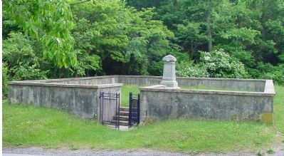
(front)
9th Army Corps.
September 14, 1862.
Reno.
(west side)
This monument marks the
spot where Major Gen. Jesse Lee Reno,
commanding 9th Army Corps U.S. Vol’s,
was killed in battle Sept. 14, 1862.
(south . . . — — Map (db m158614) WM
1838
Hagerstown appoints Richard Sheaby and Allen Barber as police constables. Two additional posts are filled in 1842.
1841
The Franklin Railroad begins service between Hagerstown and Harrisburg. The Baltimore and Ohio Railroad . . . — — Map (db m146001) HM
A native of Virginia, Fairfax served 48 years in the U.S. Navy, including service in the Mexican and Civil Wars. He retired as a Rear Admiral in 1881 and lived here at "The Columns". He rests in Rose Hill Cemetery. Highlights of his career include: . . . — — Map (db m146073) HM
Born near Nanticoke, John Henry Winder was successively a graduate and instructor at West Point. A veteran of the Seminole and Mexican wars, Gen. Winder joined the Confederacy in 1861, and eventually directed all Confederate military prisons east of . . . — — Map (db m3858) HM
Stockton House The November 9, 1872, edition of the Flint Wolverine Citizen newspaper reported the near completion of this house for retired army colonel Thomas Stockton and his wife, Maria. The newspaper called it "elegant" and "among . . . — — Map (db m178346) HM
In memory of the Soldiers & Sailors who fought in the wars of our Country
1861-1865
1812-1814
1846-1848
Erected by the Township of Flushing
A.D. 1906
1898 — — Map (db m189581) WM
The influx of miners and speculators caused concern about the lack of law and order in the region. So in March 1844, Secretary of War, William Wilkins, dispatched two companies of infantry to build and occupy a fort, that bears his name, one mile . . . — — Map (db m152892) HM
Hero of two wars. Judge. Editor. Postmaster. Diplomat. Member of Congress. An untiring servant of the people. An honor to the City of Detroit.
The Michigan Commandery of the Military Order of the Loyal Legion of the United States and citizens . . . — — Map (db m183859) HM WM
(front)
Rogers
Erected by the Texas Div.
United Daughters of the
Confederacy
the surviving members of the
family,
and admiring friends
August 15, A.D. 1912.
(back)
William P. Rogers
A native of Alabama . . . — — Map (db m89042) HM WM
A native of Tennessee, Sam Powel
(1821-1902), a Mexican War veteran,
was Colonel or the 29th Tennessee
Infantry. After the Civil War, he
moved to Hernando, where he served
as a circuit judge. Mississippi
representative and senator . . . — — Map (db m170276) HM
In 1860, John Deason, a Mexican War Veteran, organized a militia company here. The "Gainesville Volunteers" entered Confederate service in 1861 as Co. G. of the Third Mississippi Infantry. During the Civil War the unit served in the Gulf Coast . . . — — Map (db m8755) HM
Authorized on February 22, 1848, by
President James K. Polk, this camp
was situated on a peninsula just south
of Pascagoula called Greenwood Island.
The camp grounds consisted of several
buildings, including a hospital, parade
ground, and . . . — — Map (db m102205) HM
After the signing of the Treaty of Guadalupe Hidalgo in February, 1848, ending the Mexican War, 80,000 US Troops returned to the US for reassignment or discharge. To alleviate the crowded port conditions of New Orleans, Baton Rouge, Mobile, and St. . . . — — Map (db m102309) HM
Named in honor of Thomas Lawson, the Surgeon General of the Army, it was staffed by the Chief Medical Officer of Twiggs' Brigade, Surgeon John B. Porter, and Assistant Surgeons Glover Perin and Lyman Stone, U.S. Army. Located on the southern point . . . — — Map (db m102360) HM
Once a widely heralded destination, the
Cottage by the Sea Tavern, located
here, was part of a resort hotel complex
built by Charles Boster in 1872. A sea
captain and native of Germany, Boster
served in the U.S. Navy during the
Mexican War. . . . — — Map (db m197765) HM
2 mi. NW was the flourishing port of Camargo, named by veterans for their Mexican war camp. The town had a steamboat landing, schools, cemetery, and church. Confederates won a skirmish here, July 14, 1864 — — Map (db m50325) HM
On a February day in 1861 as Jefferson and Varina Davis were pruning roses on the lawn at Brierfield, their home south of Vicksburg, a messenger arrived informing Davis that he had been elected president of the Confederate States of America.
Mrs. . . . — — Map (db m104037) HM
Built c. 1845, and home of Carnot Posey, 1st Lieut., Miss. Rifles, Mexican War, and Confed. Brig-General. Wounded at Bristoe Station, Va., and d. Nov. 13, 1863. Buried Univ. of Virginia. — — Map (db m93457) HM
Born in County Tyrone · Ireland
May 10-1810
Died in Ottumwa · Iowa
June 1-1879
Soldier · Jurist · Statesman
United States Senator from
Illinois · Minnesota and Missouri
Cerro Gordo · Chapultepec
Winchester · Port Republic
Erected by . . . — — Map (db m90874) HM WM
Born in County Tyrone, Ireland
May 10, 1810
Died June 1, 1879
Rests in St. Mary's Cemetery near
Carrollton, Missouri
Soldier · Statesman
Jurist · Patriot
Brigadier General
Mexican War · Civil War
Cerro Gordo · Winchester . . . — — Map (db m90890) HM WM
One of the finest artillery units of the Civil War was Bledsoe's Battery, commanded by Col. Hiriam Bledsoe, a resident of Pleasant Hill.
Born in Kentucky, he moved at age 14 to Lexington, Mo. In 1846 he joined the U. S. Army, Missouri . . . — — Map (db m88348) HM WM
From circa 1830 until 1925 a house stood on this site once occupied by Alexander W. Doniphan. A native Kentuckian, Doniphan practiced law in Clay County for 30 years, defended the Mormons, and founded William Jewell College. During the Mexican War . . . — — Map (db m81735) HM
Born in Mason Co. Ky.
July 3, 1808,
and died at Richmond Mo.
Aug. 8, 1887
An orator, jurist, statesman,
soldier and a Christian
———————
Colonel commanding the United
States troops at the . . . — — Map (db m68106) HM WM
Early border town, prominent trading and outfitting center, and one of the farthest northwest of U. S. towns to be based on southern culture and economy. Settled about 1820, mainly by southern pioneers, the town became the seat of justice for . . . — — Map (db m81749) HM
Father of the Santa Fe Trail
William Becknell led a small group out of Franklin in 1821 on the first trip along what would be known as the Santa Fe Trail. If his trip across the Great Plains was successful, the group would make money trading . . . — — Map (db m46932) HM
Died on the Santa Fe Trail between
Council Grove, Ks. and Kansas City, Mo.
Member, Georgia State Legislature
Mexican War Veteran
First Territorial Governor of New Mexico — — Map (db m63021) HM
Alexander Doniphan (1808-1887) negotiated the 1837 Platte Purchase, which increased the size of Missouri. It included the acquisition of St. Joseph, an important waterfront town and a point of departure for the Oregon and California Trails.
As . . . — — Map (db m199440) HM
Legendary frontiersman Christopher H. "Kit" Carson (1809-1868) was a mountain man, trapper, scout, Indian agent, explorer, and guide. Some of Carson's greatest adventures took place on the Santa Fe Trail, including his initiation into the Santa Fe . . . — — Map (db m199423) HM
Erected by the State of Missouri
in honor of
Colonel Alexander W. Doniphan
Commander of First Regiment Missouri
Mounted Volunteers in the War with Mexico
Born Mason County, Kentucky, July 9, 1808
Died Richmond, Missouri, August 8, . . . — — Map (db m157143) HM
[Side A]
Richmond was founded, 1827, as the seat of Ray County on land donated by John Wollard, W.B. Martin, and Isaac and William Thornton. The county, organized 1820, had its first seat at Bluffton, where Camden, an early Missouri . . . — — Map (db m157138) HM
Panel One:
Utah Territory
The area now making up the state of Nevada was acquired by the United States after the Mexican-American War. This newly acquired land was generally labeled as unorganized territory until 1850. The State of . . . — — Map (db m227650) HM
Lake's Crossing, a growing community along the Truckee River in Northern Nevada, was parceled into a proper town site by the Central Pacific Railroad. The railroad named the town Reno, to Honor Major General Jesse Lee Reno.
Born April 20, . . . — — Map (db m77708) HM
Hillsborough dedicates this memorial in recognition of the service rendered by its citizens in the wars of our country 1775 • 1812 • 1846 • 1861 • 1898 • 1917 — — Map (db m152125) WM
Lies buried in nearby Minot enclosure. Native son of New Hampshire, graduate of Bowdoin College, lawyer, effective political leader, Congressman and U.S. Senator, Mexican War veteran, courageous advocate of States’ Rights, he was popularly known as . . . — — Map (db m77802) HM
Side 1:
In memory of the 155 men of Candia who served in the War of Revolution
Killed: Lieut T Dearborn, P Hills
In memory of the 5 men of Candia who served in the French and Indian War of 1756
Side 2: In honor of the 126 men of . . . — — Map (db m105524) WM
While his father Capt. John Porter, U.S.N.
Commanded the Portsmouth Navy Yard.
Graduated West Point, July 1845
Distinguished himself and was wounded in War with Mexico
1846-1847.
Instructor of Artillery and Cavalry
West Point . . . — — Map (db m94764) HM
Born March 23, 1802, in Trenton.
Captain Yard was involved in the export and manufacture of bristled brushes, which proved to be lucrative, but lost his fortune in 1835 due to the wars in Europe. He later was appointed principal keeper of New . . . — — Map (db m9892) HM
These two Model 1841 6-Pounder field cannons were used by United States artillery until 1868. They weigh 800 pounds, fired a shot (projectile) with a weight of 6.1 pounds, and had a range of 1,500 yards. This smoothbore gun was the most common army . . . — — Map (db m119551) HM
Point of Rocks was a convenient camping spot for Santa Fe Trail travelers going in both directions. When the caravans camped here going west they knew they were two weeks from the end of their 900-mile journey. Here they would have their first . . . — — Map (db m156696) HM
One of the few battles of the Mexican War to be fought in New Mexico occured near here on Christmas Day, 1846. U.S. troops under Colonel Alexander W. Doniphan defeated a Mexican army commanded by General Antonio Ponce de León. Two days later, . . . — — Map (db m6552) HM
In 1849, following the Mexican War, fields were first broken in Las Cruces. The town became a flourishing stop on the Camino Real, deriving its name, "The Crosses", from the marking of graves of victims of an Apache attack. Las Cruces since 1881 has . . . — — Map (db m60679) HM
I. The laws of the United States having been extended by proclamation over the Mesilla Valley and the territory recently acquired from the Republic of Mexico, the undersigned as military Commander of the same directs that Lt. Colonel Miles 3rd . . . — — Map (db m6991) HM
The 1848 Treaty of Guadalupe Hidalgo ended the Mexican-American War, establishing Mesilla as a Mexican holding. Cura Ramon Ortiz settled families from El Paso del Norte and pre-territorial New Mexico here. Disputes over the border just north of town . . . — — Map (db m119926) HM
[English Translation Marker:]
The first international monument of the 276 monuments installed to the west along the international land boundary which marks the international boundary between the United States and Mexico. This monument . . . — — Map (db m38105) HM
Here the Camino Real between Santa Fe and El Paso passed along the eastern bank of the Rio Grande near a brazito, or small branch of the river that created a small island. At this paraje, or stopping place, American troops defeated a . . . — — Map (db m38148) HM
On November 28, 1846 the Mormon Battalion of the U. S. Army West crossed these mountains near this summit enroute to California during the Mexican War. Col. Cooke had dispatched scouts ahead to find the best route. An Indian guide, Charbonneau, . . . — — Map (db m91987) HM
Pancho Villa State Park commemorates the historic Columbus Raid of 1916. Ruins of Camp Furlong, headquarters for General John Pershing's expeditionary force, still exist at the park. The old Columbus Customs Service building has been restored to . . . — — Map (db m81737) HM
Here crossed the first road to Southern California opened for wagons by Capt. Cooke, who passed here in command of the Mormon Battalion, Nov. 1846 – later it became the California Emigrant Road – from 1858-1861, the route of the . . . — — Map (db m38302) HM
On the indigenous pathway that became the Santa Fe Trail, Native Americans long traveled and traded. After Mexico gained independence from Spain in 1821, the Santa Fe trail developed as an international commercial highway connecting Mexico with the . . . — — Map (db m156800) HM
The Mexican-American War had just begun in 1846, when Brigadier General Stephen Watts Kearny brought a regiment of U.S. soldiers and volunteers from the Missouri River into Las Vegas. From a rooftop overlooking the Las Vegas plaza he proclaimed . . . — — Map (db m236778) HM
Las Vegas served as an important stop on the Santa Fe Trail and later as a major railroad center. Here General Kearny announced the annexation of New Mexico by the U.S. in 1846. In 1862, during the Confederate occupation of Santa Fe, Las Vegas . . . — — Map (db m45887) HM
Mr. Acalde, and people of New Mexico: I have come amongst you by the orders of my government, to take possession of your country, and extend over it the law of the United States, we consider it, and have done so for some time, a part of the . . . — — Map (db m148846) HM
The Mormon Battalion
Council Bluffs, July 16, 1846
Fort Leavenworth, Aug. 2, 1846
Santa Fe, Oct. 9, 1846
San Diego, Jan 29, 1847
Erected June 16, 1940
[ Map of Mormon Battalion Route ]
The Mormon Battalion, composed . . . — — Map (db m150860) HM
1848
The 1848 Treaty of Guadalupe Hidalgo ended two years of war between
Mexico and the United States. New Mexico, along with Arizona, California
and parts of Nevada, Utah and Colorado were now a part of the United
States. A group led by . . . — — Map (db m182410) HM
In May of 1846, U.S. President James K. Polk ordered the invasion of Mexico by U.S. troops, thus beginning the Mexican War. Three months later, General Stephen Watts Kearney led a victorious U.S. Army unopposed across northern New Mexico and into . . . — — Map (db m76263) HM
Strategically located where the Santa Fe Trail emerges from Glorieta Pass, Cañoncito is where the New Mexico Governor Manuel Armijo weakly defended New Mexico against the American Army in 1846. In 1862, Union forces destroyed a Confederate supply . . . — — Map (db m119815) HM
The building you see in front of you, called the Hewett House, is one of the few remaining military buildings dating
from the period when the U.S. Army maintained two military reservations in Santa Fe (1846-1894). This adobe
building was one of . . . — — Map (db m182031) HM
U.S. President James K. Polk assigned the invasion of New Mexico and California to General Stephen Watts Kearny, who marched the Army of the West into Santa Fe on August 18, 1846. Governor and Commanding General Manuel Armijo had publicly demanded . . . — — Map (db m184792) HM
Near to where you are standing is the route of one of the great overland trails of one of the great overland trails of the old west. Established in 1821, as a trade route between Franklin, Missouri, in the United States, and Santa Fe, then part of . . . — — Map (db m185096) HM
Fort Marcy was constructed in 1846 at the outset of the Mexican-American War by the U.S. Army following the invasion and capture of the Mexican city of Santa Fe. The Americans built a fort atop this hill to protect the troops in the case of an . . . — — Map (db m183673) HM
You are standing on Fort Marcy Hill, a site of human occupation for a thousand years. Pueblo Indians and their ancestors lived here. Between 1600 and 1680, the hill was common land for Santa Fe colonists. The Spanish built a small fort on a hill . . . — — Map (db m184791) HM
"History may be searched in vain for an equal march of infantry"
Lt. Col. Cooke
The Mormon Battalion, of some 500 men marched through this area during November of 1846. The march covered over 2000 miles from Council Bluffs, Iowa to San . . . — — Map (db m38297) HM
Near where you are standing was
one of the great overland trade
routes of the 19th century.
Connecting Franklin, Missouri,
with Santa Fe, New Mexico, the
trail ran 900 miles through rough
terrain hostile to all but the hardiest
traders set . . . — — Map (db m162262) HM
A square rigged Sloop-of-War built in 1844 at Washington Navy Yard from 1845 to 1847 she served as part of the Naval forces in the Mexican War. Following that she served in the Pacific Squadron until 1874.
From 1875 to 1908 the St. Marys was . . . — — Map (db m193311) HM
1861-1865
Lenox and Canastota's
Tribute to Their Heroes.
Erected A.D. 1907
(dates on monument)
1776-1783
1812-1815
1846-1848
1898 — — Map (db m149176) WM
Presented to the Village of Cazenovia by Cazenovia Post No. 66 American Legion in commemoration of those who served from this community in the wars of the United States — — Map (db m246830) WM
This small square marks the grave of General William Jenkins Worth (1794-1849). Born to Quaker parents in Hudson, New York, Worth worked briefly at a store in Hudson before moving to Albany to pursue a mercantile career. With the outbreak of the . . . — — Map (db m147146) HM
William J. Worth, born in Hudson, New York Began his military career in the War of 1812 and from 1820 to 1828 was Commandant of Cadets at West Point. In the Mexican-American War, he distinguished himself in battles inscribed on this monument. . . . — — Map (db m147148) HM
To commorate the purchase three hundred years ago of Governors Island by Wouter van Twiller, Director General of New Netherlands, from Cakapeteyno and Pehiwas of the Manahatas Tribe.
Birthplace of American Military Tactics which won for England a . . . — — Map (db m21158) HM
Winfield Scott House
Has Been Designated a
National Historic Landmark
This Site Possesses National Significance
In Commemorating the History of the
United States of America
1974
National Park Service
United States Department of the . . . — — Map (db m141238) HM
Gen. John J. Peck
Born here Jan. 4, 1821; Won promotion for gallantry Mexican War; Made Maj. Gen. 1862; Defended Suffolk, VA; Died Syracuse, April 21, 1878. — — Map (db m223701) HM
Here rests the remains of
Colonel
John Lind Smith
U.S. Corps of Engineers
who died 13th December 1858
aged seventy years and was here
interred with military honors.
He was greatly respected by his
brother officers. . . . — — Map (db m216930) HM WM
The Mexican War increased the nation’s size by over 20 percent and continued the rapid territorial expansion of the United States. In 1846, after a number of incidents along the border between Texas and Mexico, the United States declared war . . . — — Map (db m22277) HM
The cannon on this historic site are trophies of war. They were captured or surrendered in American conflicts through more than two hundred years. The first trophies to come to West Point were guns captured in 1777 during the Battles of Saratoga. . . . — — Map (db m54930) HM
Born Dinwiddie Co. Va. June 13, 1786 Died West Point, N.Y. May 29, 1866 --------------- History records his Eminent Services as a Warrior, Pacificator and
General In Chief of the Armies of the United States. Medals and an Equestrian Statue . . . — — Map (db m37169) HM
This stone is erected to Major General John Ellis Wool. The gallant soldier, the able commander, and the patriotic citizen. Distinguished in many battles; and to Sarah Moulton, his excellent and worthy consort. ---------- Queenstown, October 13, . . . — — Map (db m81739) HM
Home of Captain Martin John Burke,
b. 1816-d. 1847, graduated from West Point 1836; was killed in war
with Mexico Aug. 20, 1847. — — Map (db m138752) HM
Territorial Governor of Oregon, 1848-50,
Vice-Presidential candidate, 1860, U.S.
Senator, major general in Mexican War.
Born 3 miles east. — — Map (db m31534) HM
In honor of
Braxton Bragg
Lieutenant Colonel, USA
General, CSA
Born: Warrenton N.C.
22 March 1817
Died: Galveston, Texas
27 September 1876
War Department General Order No. 77, 21 August 1918, established Camp Bragg, N.C. in . . . — — Map (db m62493) HM WM
"Duty is the sublimest word in our language. Do your duty in all things. You cannot do more. You should never wish to do less."
Born January 19, 1807 at Stratford Hall, Westmoreland County, Virginia.
Son of Henry "Light Horse Harry" . . . — — Map (db m245028) HM
Major general in the Confederate Army, lieut. colonel in Mexican War, general in Egyptian Army, 1870-79. His birthplace was 1 bl. W. — — Map (db m28624) HM
The Walnut Grove Cemetery is the burial place of members of the Zane and Martin families. Their graves lie within the brick enclosure. The cemetery is also the resting-place of many early Martins Ferry residents, including veterans of the . . . — — Map (db m28444) HM
To honor General Zachary Taylor and all U.S. Soldiers (Dragoons) who served during the Mexican War to preserve U.S. Territory.
May 13, 1846 May 30, 1848 — — Map (db m166190) WM
Honoring the Memory of Franklin County Soldiers of the Mexican War 1846 - 1848 On this day, October 2, 1954, this tablet is placed in memory of those soldiers from Franklin County, Ohio who served their country with great courage and . . . — — Map (db m13106) HM
Roswell S. Ripley was born in Worthington on March 14, 1823 and graduated from the United States Military Academy in 1843. Serving with the U.S. Artillery from 1846 to 1848 during the Mexican-American War, Ripley was promoted twice for . . . — — Map (db m2050) HM
Spanish American War Veterans.
Aldrich, William •
Barnes, Harry A. •
Barnes, James W. •
Barrent, Harry •
Biddle, Charles E. •
Barhite, Harry G. •
Bowers, Chris •
Bruning, Augustus •
Bayes, C. A. •
Beil, John J. •
Bunting, . . . — — Map (db m173812) WM
749 entries matched your criteria. Entries 301 through 400 are listed above. ⊲ Previous 100 — Next 100 ⊳