On Gateway Drive, 0.1 miles west of North East Road (Maryland Route 272), on the left when traveling west.
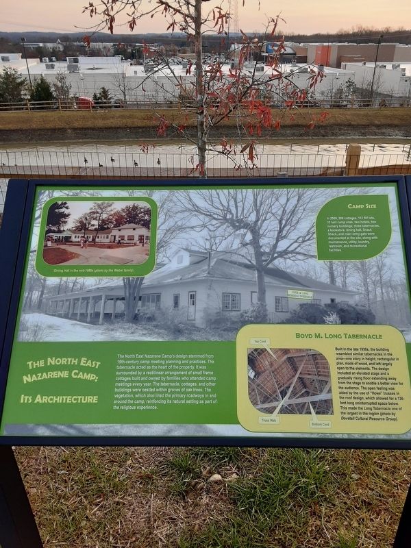
The North East Nazarene Camp's design stemmed from
19th-century camp meeting planning and practices. The
tabernacle acted as the heart of the property. It was
surrounded by a rectilinear arrangement of small frame
cottages built and owned by . . . — — Map (db m162876) HM
On Gateway Drive, 0.1 miles south of Nazarene Camp Road, on the left when traveling north.
[Column work is from right to left in the transcribing of this plaque's contents.]
The North East Nazarene Camp Meeting provided a
respite from chaotic daily life. The social aspects of
the camp were just as important as the . . . — — Map (db m163112) HM
On Gateway Drive west of North East Road (Maryland Route 272), on the left when traveling west.
This property was once the North East Nazarene Camp. The Holiness Christian Church, which became part of the Pentecostal Church of the Nazarene, was founded in 1894 as a branch of Methodism. In 1909, a temporary summer Holiness Nazarene camp . . . — — Map (db m163888) HM
On Jacob Tome Memorial Highway at Dr Jack Rd / Craigtown Rd, on the right when traveling east on Jacob Tome Memorial Highway.
To St. Mary Anne’s Church, North Elk Parish, North East, Maryland. Built in 1733, the oldest remaining gravestone in 1968 records the death of Thomas Shepherd, August 28, 1742. — — Map (db m92330) HM
On Camp Meeting Ground Road at Principio Road, on the right when traveling west on Camp Meeting Ground Road.
Established by the Methodist Episcopal Church in 1871, the camp was a popular center of religious and social life. Political candidates and vacationers attended the two-week meetings in August. Its forty-two year era ended in 1913. — — Map (db m24111) HM
On Jacob Tome Memorial Highway (Route 276) at Cowan Road, on the right when traveling north on Jacob Tome Memorial Highway.
Founded 1744 by by Rev. Sam’l Finley a Presbyterian Minister and a native of Armaugh County, Ireland. He remained in charge of the academy and church until 1761 when he was chosen President of the College of New Jersey, now called . . . — — Map (db m145625) HM
Near Brick Meeting House Road, 0.2 miles west of Maryland Route 272, on the right when traveling west.
In memory of the Unknown Soldiers buried at Brick Meetinghouse while it was used as a hospital in 1778.
[at marker bottom]
May 30, 1929 — — Map (db m147741) HM
On Conowingo Road (U.S. 1) at Slicers Mill Road, on the right when traveling west on Conowingo Road.
Founded 1744 by by Samuel Finley, Presbyterian Minister and a native of County Armagh, Ireland. He remained in charge of the academy and church until 1761 when he was chosen President of the College of New Jersey, now Princeton University. — — Map (db m145628) HM
On Cecilton-Warwick Road (Maryland Route 282) at Worsell Manor Road on Cecilton-Warwick Road.
Patented 5th June, 1685, to Major Peter Sayer, a prominent Catholic. Later acquired by the Heath Family. On 14th May, 1773, George Washington “din’d and lodg’d at Mr. DL. Heath’s” taking his stepson Jackie Custis to King’s College, N.Y. . . . — — Map (db m65392) HM
This replica of the Maryland Colonists’ Wrought Iron Cross of 1634 stands directly over the south foundation wall of the original house-chapel-academy building (circa 1720-1745) — — Map (db m69828) HM
On Main Street (Maryland Route 282) at Church Road, on the right when traveling west on Main Street. Reported missing.
Founded 1704 by Rev. Thomas Mansell, S.J., one of the earliest permanent Catholic establishments in the English Colonies.
Bohemia Academy Founded 1745 by Rev. Thomas Pulton, S.J. attended by Charles Carroll of Carrollton, a signed of the . . . — — Map (db m244190) HM
On Olivers Shop Road (Maryland Route 232) 1.2 miles south of Leonardtown Road (Maryland Route 5).
In 1700 a frame chapel ministered by Jesuit missionaries was attached to the home of Major William Boardman. Father David erected a church in 1793. Under Father Courtney in 1845 a new brick church was begun which is the middle section of the present . . . — — Map (db m925) HM
On Olivers Shop Road (Maryland Route 232) 1.2 miles south of Leonardtown Road (Maryland Route 5).
On November 13, 1864, here at St. Mary’s Catholic
Church, Dr. Samuel A. Mudd was introduced to John
Wilkes Booth, the future assassin of President Abraham Lincoln. Booth had come to Charles County to
contact the Confederate underground here and . . . — — Map (db m924) HM
On Strauss Avenue at Milburn Place on Strauss Avenue.
This is the site of Saint Charles Roman Catholic Church. The parish began as a “Station Chapel” in the nearby home of the Charles Pye Family. Priests from St. Thomas Manor House in Port Tobacco came by on horseback to minister to the people. Saint . . . — — Map (db m6738) HM
One of the original thirty parishes established by an act of the General Assembly of Maryland on June the 2nd 1692. A log church was first erected on this site as reported by the vestry to the Governor in 1694. Existing church was constructed in . . . — — Map (db m128786) HM
On Mitchell Road at Mount Carmel Road, on the right when traveling north on Mitchell Road.
First Carmel in U.S. Founded October 15, 1790, by four Carmelites from Belgium three of them natives of Maryland. Nuns moved to Baltimore Sept. 13, 1831. The restorers of Mt. Carmel in Md Recoverd site March 27, 1935. Restored buildings 1937. — — Map (db m6228) HM
On Crain Highway (U.S. 301) at Old Stage Coach Road, on the right when traveling south on Crain Highway.
Job Chandler, first Charles County settler, built the oldest part of this house, 1639-1650, aided by the Potopaco Indians. Later it was the birthplace of Archbishop Leonard Neale, one of six brothers, all Catholic priests, and one sister, a nun. . . . — — Map (db m6741) HM
On East Charles Street (Maryland Route 6) at Church Street, on the right when traveling east on East Charles Street.
Parish church of Port Tobacco Parish, one of the 30 Church of England parishes established, 1692, by act of the provincial assembly, supported by a yearly poll tax of 40 pounds of tobacco. In 1904 the edifice was moved stone by stone from Port . . . — — Map (db m1073) HM
On Crain Highway (U.S. 301) at Port Tobacco Road (Maryland Route 6), on the right when traveling south on Crain Highway.
11.8 miles West near Ironsides, MD. Oldest church in Charles County. Served by thirty rectors through 257 years. Present building erected 1732. Visited by George Washington 1771. Restored by Governor Smallwood 1791. — — Map (db m36840) HM
Near Riverside Road (County Route 224) 1.1 miles south of Liverpool Point Road (Route 426).
Open Fields and a Wooden House
These chimneys remain from a house, called Mount Pleasant, which was built in 1798. Though trees now cover the land, in the 18th and 19th-centuries, active farms covered this area. Facing this direction, a . . . — — Map (db m129206) HM
On Baptist Church Road, 0.3 miles east of Port Tobacco Road (Route 6) when traveling east.
Organized in 1793
United with the Maryland Baptist Union Association (Now Baptist Convention of Maryland) in 1837
"In 1790 four men from Virginia crossed the Potomac River and started preaching the Gospel in Nanjemoy the Sanctuary which . . . — — Map (db m135469) HM
On Rock Point Road (Maryland Route 257) 0.1 miles north of Morgantown Road, on the right when traveling north.
Known originally as Piccawaxen, the parish was re-named William and Mary under the Establishment Act of 1692.
Christ Church, in existence in 1690, enlarged in 1750, is otherwise unchanged except for post civil war repairs.
The boyhood . . . — — Map (db m128806) HM
On Marshall Corner Road (Maryland Route 227) at St. Joseph's Way, on the left when traveling east on Marshall Corner Road.
The eighteenth century merchant who died in 1804 is buried here. He willed his modest wealth to establish free schools for the education of poor children in this section of Charles County where he worked as a peddler and storekeeper for many years. . . . — — Map (db m6234) HM
On Commerce Street, 0.1 miles west of Chapel Point Road, on the right when traveling west.
On this ground, two cultures — Indian and European — confronted one another. Here a commercial town and government center grew, declined, grew again, and declined again. Residents raised supplies for the Continental Army and, . . . — — Map (db m142892) HM
On Chapel Point Road, 0.5 miles Aries Road, on the right when traveling west.
Above the icy waters of Port Tobacco Creek, flames swept through the halls of Saint Thomas Manor Complex.
The chimney fire of December 1866 gutted the complex, leaving a skeleton of smoldering brick walls. But local Jesuit churches and schools . . . — — Map (db m129126) HM
On Chapel Point Road, on the right when traveling west.
The Manor Land was acquired in 1649, under Lord Baltimore's "Conditions of Plantation." The Chapel was built probably in 1662, the manor house in 1741. Bishop Carroll laid the cornerstone of the present church in 1798. Here occurred in 1805 the viva . . . — — Map (db m70788) HM
On Chapel Point Road, 4 miles south of Port Tobacco Road (Maryland Route 6).
Dating from 1662 the oldest continuously active parish in the United States. Founded 1641 by Father Andrew White, S.J., who named Chapel Point. Present church built 1798. St. Thomas Manor has been a Jesuit residence since its erection in 1741. — — Map (db m128828) HM
Near Rose Hill Road, 0.6 miles south of Wembly Place, on the right when traveling south.
For almost four centuries, the Stone family of Maryland has contributed its talents and skills to the colony, the state, and the nation in its various capacities.
From a signer of the Declaration of Independence to two governors of Maryland, to . . . — — Map (db m142895) HM
On Chapel Point Road, 0.5 miles west of Aries Road, on the left when traveling west.
A working farm provided a refuge for religion at the cost of freedom for enslaved laborers.
The history of Saint Ignatius Church reaches back to the English colony of Maryland. Lord Baltimore, the colony's founder, recruited Jesuit priests to . . . — — Map (db m129121) HM
On Chapel Point Rd, 0.5 miles west of Aries Road, on the right when traveling west.
Captain John Smith Chesapeake National Historic Trail
This unique trail is designed for you to experience by boat. It is America’s first waterway national historic trail and includes more than 3,000 miles explored by Captain John Smith. . . . — — Map (db m135485) HM
On High Street, on the right when traveling north.
Original home of Rev. Daniel Maynadier, who served as rector of the Great Choptank Parish from 1765-1772.
Rebuilt in 1840 by Henry Page a distinguished lawyer and state senator. — — Map (db m114733) HM
On Washington Street (Maryland Route 343) at Ocean Gateway (U.S. 50), on the right when traveling west on Washington Street.
When Harriet Tubman engaged with the Underground Railroad, she tapped into a secret network of people who firmly believed it was time to end slavery. There were always some enslaved people who seized opportunities to flee to freedom, but by the . . . — — Map (db m205003) HM
On Pine Street at Bethel Street, on the left when traveling north on Pine Street.
In the 1780s, African American Methodists in Philadelphia and Baltimore walked out of white-controlled Methodist churches to protest discriminatory treatment. In 1816, these independent black Methodists from Philadelphia, Baltimore and elsewhere . . . — — Map (db m138278) HM
The original church erected year 1693 was destroyed and restored year 1794 and again rebuilt in year 1863. The wall was erected year 1762. The grounds contain graves of Revolutionary and other war heroes. Also of men famous in state and country. — — Map (db m73052) HM
On High Street south of C Street, on the right when traveling south.
Perhaps one of the oldest buildings in Cambridge, the Bayly home was lived in by affluent and accomplished Maryland families. Although we know a fair amount about Dr. Alexander Hamilton Bayly, there is little known about the dozens of enslaved . . . — — Map (db m205047) HM
On Locust Street just east of Mill Street, on the left when traveling west.
The first American Methodist Bishop, Frances Asbury appointed Freeborn Garrettson as pastor to five Methodist Societies in Dorchester County in 1779. The societies grew into congregations of Methodist Episcopal Churches; Zion Methodist Episcopal . . . — — Map (db m138285) HM
On Hoopers Island Road (Maryland Route 335) 0.8 miles west of Smithville Road, on the right when traveling west.
Built before 1767 by Richard Tubman II, to serve the Roman Catholics who had worshipped in this area since the second half of the 17th century. Early unmarked burial vaults on site.
Chapel enlarged in 1819 and in 1868. Suppressed and sold in . . . — — Map (db m154339) HM
On Old Madison Road, on the right when traveling east.
Founded 1840 at “Tobacco Stick” Gethsemane was first pastored by Dr. E.F. Ewell in a country Schoolhouse, then in a converted barn. The final building was purchased in 1860, rebuilt in 1892 and razed in 1986. — — Map (db m114977) HM
Harriet Tubman was born nearby on Harrisville Road at the Anthony Thompson plantation around 1822, where Thompson enslaved her father, Ben Ross, and about 40 other people. While Tubman’s roots began near here, she moved to Bucktown during her . . . — — Map (db m126547) HM
On Hoopers Neck Road, 1.5 miles north of Taylors Island Road (Maryland Route 16), on the left when traveling north.
The original chapel was built on this site which was donated by Moses and Elizabeth LeCompte. The deed, dated September 15, 1787, is the oldest one on record for Methodist Episcopal Church land in Dorchester County. Both Bishop Francis Asbury and . . . — — Map (db m4042) HM
On Hoopers Neck Road, 0.6 miles north of Taylors Island Road (Maryland Route 16), on the right when traveling north.
In the selection of the middle point between the Atlantic Ocean and the Chesapeake Bay for the start of the Mason-Dixon Line survey, this area was the center of a long controversy among British, Maryland and Pennsylvania officials as to whether . . . — — Map (db m4043) HM
This building was constructed sometime between 1707 and 1720 as a Chapel of Ease for members of Dorchester Parish who lived too far away from their parish church; Old Trinity Episcopal Church in Church Creek, MD, to conveniently attend services. . . . — — Map (db m114987) HM
Built in 1873 a cost of $3,500, Grace Episcopal Church was constructed as a replacement for the Chapel of Ease, now located next door to the Church, and was a part of the Dorchester Parish of the Episcopal Church. Its parent church was Old Trinity . . . — — Map (db m114986) HM
Founded in 1876 as Jefferson Methodist Episcopal Church, New Revived United Methodist Church was one of five African American congregations established in this vicinity between 1864 and 1880. These churches were rooted in faith communities that . . . — — Map (db m78782) HM
On Old Trinity Church Road, 0.3 miles north of Taylor Island Road (Route 16).
This church was built prior to 1690. In the graveyard are buried Governor Thomas King Carroll, many revolutionary heroes and other distinguished Marylanders. — — Map (db m177544) HM
Dorchester Parish c. 1675-1690
Built by English colonists on land patented in 1675 to Henry Aldridge, a former indentured servant, Old Trinity Church is one of the oldest church buildings in the United States still used for regular worship. . . . — — Map (db m97216) HM
On Buckeystown Pike (Maryland Route 80), on the right when traveling west.
To your left is a street scene of the intersection in Buckeystown around 1899. The house immediately on your left was built around 1898 as the residence for the superintendent of the Buckingham School for Boys, located south of town (now . . . — — Map (db m90488) HM
On East Main Street at Potomac Street (Maryland Route 17), on the right on East Main Street.
Union surgeons turned Burkittsville, a quiet rural village of some 200 people, into a hospital complex after the September 14, 1862, Battle of Crampton’s Gap. The building in front of you, the German Reformed Church, was Hospital D. . . . — — Map (db m190155) HM
In Memoriam
Amleto Cardinal Cicognani
Apostolic delegate to the United States 1933-1958
Cardinal Secretary of State 1958-1973
Under Pope John XXIII - Paul VI
While serving as apostolic delegate to the United States Amleto . . . — — Map (db m166875) HM
Near South Seton Avenue (Business U.S. 15) 1.7 miles north of Catoctin Mountain Highway (U.S. 15), on the right when traveling north.
Elizabeth Ann Bayley Seton founded the Roman Catholic community of the Sisters of Charity of Saint Joseph's here in 1809 (in1 1850, merged with the Daughters of Charity). The sisters played a prominent role during the Civil War as nurses and . . . — — Map (db m147294) HM
On West Main Street (Maryland Route 140) at South Seton Avenue (Business U.S. 15), on the left when traveling west on West Main Street.
After playing host to native peoples for centuries, Catoctin Mountain has served home to European settlers since the 1730's. Among the first to come to what was considered "the backlands of the province," were descendants of English Catholics who . . . — — Map (db m130244) HM
Near Catocin Mountain Highway (U.S. 15), in the median.
After playing host to native peoples for centuries, Catoctin Mountain has served home to European settlers since the 1730’s. Among the first to come to what was considered “the backlands of the province” were descendants of English Catholics who . . . — — Map (db m203969) HM
Near Catoctin Mountain Highway (Route 15) south of North Seton Avenue (Business U.S. 15), on the right when traveling south. Reported permanently removed.
Located at the intersection of the Journey Through Hallowed Ground National Scenic Byway and the famed Mason-Dixon Line, Emmitsburg remains a popular pilgrimage site and gateway to regional recreational and heritage attractions. Boasting two . . . — — Map (db m217370) HM
Near South Seton Avenue (Business U.S. 15) 1.7 miles north of Catoctin Mountain Highway (U.S. 15), on the right when traveling north.
On the last day of June 1863, Emmitsburg became a Union army supply base. Union Gen. John F. Reynolds, commanding the left wing of the Army of the Potomac (I, III and XI Corps), arrived as I Corps came into Emmitsburg to obtain needed supplies, . . . — — Map (db m147296) HM
Near Catoctin Mountain Highway (U.S. 15) south of North Seton Avenue (Business U.S. 15), on the right when traveling south.
Dedicated in memory of
Monsignor Hugh J. Phillips
Former President of nearby Mount Saint Mary's College and Seminary (now University) and longtime Chaplain of the National Shrine Grotto of Lourdes for his tireless efforts to have a Maryland . . . — — Map (db m217373) HM
Near Grotto Road, 0.6 miles north of St. Anthony's Road, on the right when traveling north.
Here on Sunday afternoons Mother Seton "seated on a rock known as Hers," taught Christian Doctrine to the children of The Mountain Parish.
"They that instruct many to Justice shall Shine as the Stars for all Eternity." - Daniel XII, 3. — — Map (db m19031) HM
Proclaimed a Public Oratory, December 8, 1965 by His Eminence, Lawrence Cardinal Shehan, Archbishop of Baltimore.
The faithful who out of devotion visit the Grotto of Our Lady of Lourdes may gain the following special indulgences: A Plenary . . . — — Map (db m92525) HM
On Grotto Road, 0.5 miles north of St. Anthony Rd.
Ave Maria
This monument is dedicated to the glory of God and His Blessed Mother.
It is erected on the site of the “Old Church on the Hill,” which was built in 1805 Father John Dubois, founder of Mount Saint Mary’s . . . — — Map (db m17360) HM
On Grotto Road, 0.6 miles north of St. Anthony's Road, on the right when traveling north.
Describing the conversion of her sister-in-law, Harriet: Harriet left the log house on the evening of Friday, July 21, 1809, between 10 and 11 o'clock to seek the solitude of the Old Church on the Hill... "Harriet stealing up to the church by the . . . — — Map (db m19034) HM
Near South Seton Avenue (Business Route 15) 1.7 miles north of Catoctin Mountain Highway (U.S. 15), on the right when traveling north.
Saint Elizabeth Ann Seton (1774-1821)
Mother + Convert + Educator + Foundress
[Plaque near the base of the statue:]
Saint Elizabeth Ann Seton
Foundress
Sisters of Charity
of
Saint Joseph's
31 July 1809 . . . — — Map (db m147285) HM
On Grotto Road, 0.6 miles north of St. Anthony's Road, on the right when traveling north.
This cross marks the site of Father Dubois house in which Mother Seton and her associates lived from Jun 21, to July 31, 1809.
"Blessed be God in His Angels and in His Saints." — — Map (db m19033) HM
On South Seton Avenue (Business U.S. 15), on the right when traveling north.
Born Aug. 28, 1774, in New York, she came to Emmitsburg from Baltimore June 24, 1809, occupying stone house on these grounds July 31. The following year, in White House visible from here, she organized nation's first Roman Catholic Parochial . . . — — Map (db m9473) HM
Near South Seton Avenue (Business U.S. 15) 1.7 miles north of Catoctin Mountain Highway (U.S. 15), on the right when traveling north.
About 38,000 Union troops from three corps passed through Saint Joseph's Valley during the five days before the Battle of Gettysburg, until it seemed to the sisters that "the grounds around were actually covered with Soldiers." Emmitsburg was . . . — — Map (db m204242) HM
Near South Seton Avenue (Business U.S. 15) 1.7 miles north of Catoctin Mountain Highway (U.S. 15), on the right when traveling north.
Bells pealed throughout Saint Joseph's Valley with the joyful news of Mother Seton's beatification March 17, 1963
The Academy Bell, cast by George Harley of Philadelphia (n.d.), summoned boarding and day pupils of Saint Joseph's Academy to . . . — — Map (db m147288) HM
Near South Seton Avenue (Business U.S. 15) 1.7 miles north of Catoctin Mountain Highway (U.S. 15), on the right when traveling north.
This is the first statue of Mother Seton erected in the United States. It was blessed on September 27, 1950, by Bishop John M. McNamara, Auxiliary Bishop of Washington, and unveiled by Francesca Senese - Santoponte of Leghorn, great-great . . . — — Map (db m147293) HM
On Grotto Road, on the right when traveling north.
John Hughes, class of 1826, fourth bishop (1838) and first archbishop of New York (1850-1864), born in County Tyrone Ireland (1797), immigrated in 1817. A gardener and mason, Hughes was employed the 10th of November, 1819, by Fr. John DuBois . . . — — Map (db m9621) HM
Near South Seton Avenue (Business U.S. 15) 1.8 miles Catoctin Mountain Highway (U.S. 15), on the right when traveling north.
June 21, 1809
Mother Seton
and her companions removed from Baltimore to Emmitsburg. For a few weeks the little company were domiciled in the mountain house placed at their disposal by
· Rev. John Dubois, S. S. ·
President . . . — — Map (db m147284) HM
On West Main Street (Maryland Route 140) at South Seton Avenue (Business U.S. 15), on the left when traveling west on West Main Street.
For more than 200 years, people have journeyed to Emmitsburg for inspiration, enlightenment, and remembrance. Located just south of the Mason-Dixon Line on one of America's Scenic Byways, the town is the site of two internationally-recognized . . . — — Map (db m147281) HM
Near Catoctin Mountain Highway (Route 15) south of North Seton Avenue (Business U.S. 15), on the right when traveling south.
For more than 200 years, people have journeyed to Emmitsburg for inspiration, enlightenment, and remembrance. Located just south of the Mason-Dixon Line on one of America's Scenic Byways, the town is the site of two internationally-recognized . . . — — Map (db m217371) HM
Near South Seton Avenue (Business U.S. 15), on the right when traveling north.
This reconstruction log building, faced with clapboard and painted white, was occupied by Mother Seton and her little community in February 1810. At the close of the year the school numbered thirty boarders and forty day pupils. In 1817 this . . . — — Map (db m9617) HM
On Grotto Road, 0.6 miles north of St. Anthony's Road when traveling north.
This calvary group replaces the "old wooden cross" erected by John Dubois of which Mother Seton writes in her journal for the year 1815 --- "Quiet dinner at the Grotto before the old cross, yet standing after winter storms", memorializes forever the . . . — — Map (db m19036) HM
William Elder, Sr., named this land Mount Saint Mary's & established (ca. 1743) his home "Pleasant Level" and the Elder Cemetery on the plain below. His family deeded (October 24, 1793) this mountain land for a church. In respect for the living God . . . — — Map (db m17389) HM
Near South Carroll Street north of East All Saints Street, on the right when traveling south.
Frederick County's ties to the American Civil War run deep, so it should come as no surprise that it is part of Maryland's Heart of the Civil War Heritage Area and The Journey Through Hallowed Ground National Heritage Area/National Scenic Byway. . . . — — Map (db m119144) HM
On East Church Street, on the left when traveling east.
This tablet is erected
to the Glory of God
and
in grateful recognition of those
who organized this congregation
and have maintained it for
two hundred years
1738 Congregation organized.
1743 Log church built on the Monocacy. . . . — — Map (db m14022) HM
On Bentz Street at 2nd Street, on the left when traveling north on Bentz Street.
In this Memorial Ground
which was donated to
Frederick County and Frederick City
by the Evangelical Reformed Church
of Frederick, Maryland
lie buried the following persons
[List of burials] — — Map (db m103425) HM
Near East Church Street just east of North Market Street (Maryland Route 355), on the left when traveling east.
This memorial garden dedicated for the German pioneer founders of our church. Once interred in this church yard
1738 - 1747
Johannes Verdies • Henrich Sechs • Johann Sechs • Christophel Gag • Martin Wetzel • Georg Schweinhardt • Georg . . . — — Map (db m152363) HM
Born in Enniskillen, Ireland, John McElroy came to this country in 1803 and was ordained a priest at the age of thirty-five. While pastor of St. John's from 1822 to 1845, Father McElroy built the present church on Second Street and established St. . . . — — Map (db m103237) HM
Near South Carroll Street north of East All Saints Street, on the left when traveling north.
"We may not find tolerance in the workplace or justice in the courtroom, but the church renders to us a peace of mind that few institutions can match. The church is our foundation. It continuously nurtures and inspires us."
- William O. Lee Jr. . . . — — Map (db m137785) HM
Fifth Chief Justice of
The Supreme Court of the United States
Born in Calvert County, Maryland, March 17,1777
Died in the city of Washington, October 12, 1864
Aged 87 years, 6 months and 25 days
He was a profound and able lawyer
An . . . — — Map (db m58159) HM
On West Church Street, on the left when traveling east.
circa 1745 - Founded by German Reformed settlers led by schoolmaster John Thomas Schley, the Founder of Frederick City.
1934 - Became part of the The Evangelical and Reformed Church a Merger of the Evangelical Synod and German . . . — — Map (db m2816) HM
On South East Street north of East South Street, on the left when traveling north.
[East Panel]
This bell was cast in Frederick on April 1 and 2, 2006, with public participation and great festivity. Frederick County "Honey Bee" participants in grades 3-5 helped cast the bell by passing ingots of metal to furnace . . . — — Map (db m129727) HM
Chief Justice
Of the United States
1836-1864
Secretary of the Treasury
1833-1834
Attorney General
Of the United States
1831-1833
Attorney General
Of Maryland
1827-1831
Citizen of Frederick
And lawyer practicing
in . . . — — Map (db m106648) HM
Since the 1700s, the land you are standing on was used for farming fields of corn, wheat, barley and hay. Eventually this 2 acre self sustaining farm had two barns, a nine-room home, and a cemetery. There were dairy cattle, chickens, pigs an orchard . . . — — Map (db m182235) HM
On West Main Street / Old National Pike (Alternate U.S. 40) at Garage Drive, on the right when traveling west on West Main Street / Old National Pike.
"Lot No. 1" on Jesserong's plat of Middletown as he laid it out in the year 1767. The Lutheran Parsonage and the two story "Lecture Hall Building" which was located to the front right of the parsonage and the little brick "Pastors Study" located . . . — — Map (db m5301) HM
On West Main Street (Alternate U.S. 40) just east of South Jefferson Street, on the right when traveling east.
As the Civil War approached, the citizens of Middletown read about the coming conflict in the town newspaper, The Valley Register. Some attended patriotic rallies, while others found it safer to conceal their allegiances. Soldiers from many . . . — — Map (db m143918) HM
On South Church Street (Maryland Route 17) 0 miles south of Washington Street, on the left when traveling south.
Eight thousand Confederates under Gen. Lafayette McLaws marched by this church on September 10-11, 1862, heading south to Harper’s Ferry. Since no Federals were in the area, McLaws expected no encounters with the enemy. Unknown to him, however, . . . — — Map (db m166869) HM
On Old National Pike (Alternate U.S. 40) west of Elm Street, on the right when traveling west.
This property (Lot 11-East Half) and one to the left were one lot when platted in 1768. They were separated in 1866.
During the battle of South Mountain in 1862, this site was used to triage casualties for care in the former Wesley Methodist . . . — — Map (db m68968) HM
On West Main Street near South Jefferson Street, on the right when traveling east.
This candid view of downtown Middletown shows the street corner where you are now standing. At the time, this was the town square. The shuttered brick building (right) still stands directly behind you. The log building under construction (center) is . . . — — Map (db m219991) HM
On West Main Street (Alternate U.S. 40) just east of South Jefferson Street, on the right when traveling east. Reported permanently removed.
This view of downtown Middletown was taken from the towering steeple of the Zion Lutheran Church across the street behind you. This remarkable image highlights the historic National Road—dirt at the time—running eastward toward Frederick, and (to . . . — — Map (db m219995) HM
710 entries matched your criteria. Entries 301 through 400 are listed above. ⊲ Previous 100 — Next 100 ⊳